Wright's Mountain Trails
Wright's Mountain Trails
Newbury, Vermont 05051
Wrights Mountain Trails publicationWrights Mountain Trails map
About this Location
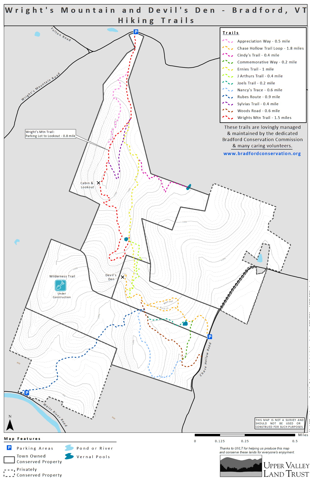
With an elevation of 1,822 feet, Wright’s Mountain is Bradford’s highest peak, with wonderful views from its open summit ledges of the Waits River Valley and surrounding mountains to the west. A 3.5-mile network of footpaths and logging roads connect trailhead parking areas on both Chase Hollow Road and Wright’s Mountain Road. The Wright’s Mountain Trail from the north is part of an “Interconnectedness Quest,” an educational treasure hunt, created with Oxbow High School students in coordination with the Vital Communities Valley Quest program. The Chase Hollow Trail from the south leads to a boulder-strewn ravine with a number of shallow caves, the largest of which is known as Devil’s Den. Ernie’s Trail connects north and south, meeting up with the Wright’s Mountain Trail at a large vernal pool on the southeast flank of Wright’s Mountain. The 218-acre Wright’s Mountain parcel was purchased from Sylvia Appleton in 1993 with funds raised by the Bradford Conservation Commission via grants, private contributions, fund-raising events, and an allocation by the voters of Bradford at Town Meeting. In April 2004 Bradford acquired the 60-acre Devil’s Den tract in a bargain sale and incorporated it into one conservation management plan with Wright’s Mountain. Through a conservation restrictions agreement with UVLT, the Wright’s Mountain/Devil’s Den area will always be conserved as wildlife habitat and forest land, and open to the public for recreation, education, and enjoyment.
Notable Trails
Chase Hollow Trailhead: From the Bradford exit of I-91, go west on VT-25 for 3.3 miles. Turn right onto Chase Hollow Road and go 1.3 miles. Trailhead parking is on the left, and the yellow-blazed trail starts at the north side of the parking lot.
Wright’s Mountain Trailhead: The Wright’s Mountain trailhead can be approached from either the east or west. From the I-91 Bradford exit, go west on VT-25 for 4.7 miles. Turn right onto Wright’s Mountain Road and go 2.3 miles, staying to the right at the Fulton Road intersection, to trailhead parking on the right. Alternatively, if you are planting a car for an end-to-end hike-through, continue from the Chase Hollow Trailhead on the Chase Hollow Road for another 1.1 miles, making sure to turn left at the intersection of Chase Hollow and Tarbox Roads at the 0.9-mile point. At the end of Chase Hollow Road, turn left again and follow Goshen Road for 0.7 miles. Turn left once more, and follow right’s Mountain Road west 1.1 miles to Wright’s Mountain trailhead parking on the left.
The TrailFinder website has a description and map of hikes at Wrights Mountain.
Features
Restrooms on site
Wheelchair accessible trail
Entrance fee
Content from Wrights Mountain Trails publication
Last updated October 9, 2023