
Tioga-Hammond Lakes


Tioga-Hammond Lakes
710 Ives Run Lane Tioga, PA 16946-8643
Official WebsiteIves Run Recreation Area Trail USACE Trail Map
Lambs Creek Hike&Bike Trail on TrailLink
Mid State Trail website
Tips for Birding
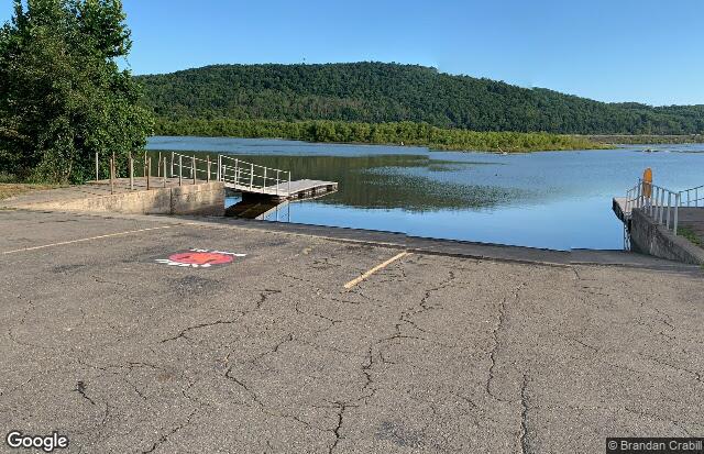
Both of the Ives Run boat launches provide views of the lake. A scope is very helpful, especially at the boat launch in the campground. These are good places to check during spring and fall migration. When the lake is not iced over, the boat launch areas are worth a look during winter months. Smaller birds can be seen just about anywhere in the park. The brush and along the stream (Tim Ives Run) crossing through the campground and picnic area can harbor a number of species.
Birding the Lambs Creek Recreation Area is best done by walking the hike/bike trail or by driving in from the main entrance from I-99/US-15. The Lambs Creek Recreation Area is for day use only. The roadway up to the picnic pavilion and bathroom facilities has been closed off. It is unknown when or if this area will reopen. The area does not have bathroom facilities unless the US Army Corps of Engineers (USACE) provides a portable toilet during the summer months. Often they do not.
Birds of Interest
Migrating waterfowl, warblers, and raptors in season. Eagles and Osprey nest in or near the park and are often seen fishing and flying over the lake. Other raptors also frequent the park.
About this Location
This location includes Ives Run Recreation area on Hammond Lake accessed from PA route 287 and Lambs Creek Recreation Area on Tioga Lake accessed from I-99/US 15. The Ives Run Recreation ARea has camping, picnic, and bathroom facilities. The Lambs Creek Recreation Area is day use only.
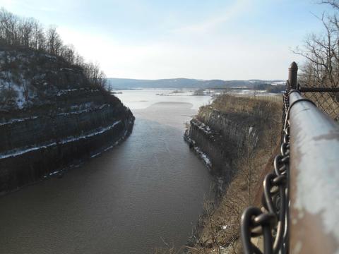
The The lakes were formed by flood control dams built after the flood of 1972 caused by Hurricane Agnes. The dams protect downstream communities from flooding. The village of Hammond was once located near the Hammond Lake. The villages of Lambs Creek, and Mill Creek and a collection of homes known as Kellytown were once located near the Tioga lake.
Notable Trails
Archery Trail is a one mile loop trail with archery targets at stations along the way. This trail is an old roadway and easy to follow. There is a grade where the trail approaches and leaves the area near the wetland but it is not steep.
C. Lynn Keller Trail is seven to nine mile loop trail with a vista from the top of the ridge. The trail is steep in places. Part of the trail is a narrow path on a steep sidehill as it climbs the ridge. It can become muddy and slippery near where the trail joins Stephenhouse Road. The trail then follows the road back to the trailhead. There are two trail heads in the park. One is near the campground area. The other is at the parking lot on the end of Stephenhouse Road where it joins the entrance road to the park. There is a connecting trail between the two trailheads. There is also an inner route that is about four miles. Biking is prohibited...and also very unsafe. An orange hat should be worn during hunting season. Current regulations require even non-hunters to wear an orange vest or jacket during deer season.
Fishing Pier Trail, for lack of a better name, is a short handicapped accessible trail to a fishing pier on Crooked Creek as it enters the lake. To access this roughly .25 mile trail take a the first left on the entrance road to the boat launch on the western end of the lake. The road will arrive at a parking area with several short loops. Go through this area and follow the short road to the small parking area. The trail leaves this area and follows the path of an old road to the fishing pier. Those who are able, can continue to where the area ends at the lake. This area can be muddy. It will be underwater when lake levels are high, especially if the gates on the dam have been closed.
Mid State Trail passes through the park on it the way from the border with Maryland to the border with New York State
Railroad Grade Trail is a 1.6 mile one way roadway following the former path of the Conrail Rail Line along Crooked Creek from the park entrance road to Hills Creek Road on the other end. There are parking areas near both ends of the trail. This trail receives vehicle traffic from people who are fishing, hunting, or just passing through. Insect repellant is a must in the summer as mosquitos are numerous and hungry. Hikers and bikers should be aware that the area along the trail is stocked for pheasant hunting and receives heavy activity during pheasant season. An orange hat should be worn during hunting season. Current regulations require even non-hunters to wear an orange vest or jacket during deer season. Typical safety precautions should be followed and it wise to be especially careful at dawn and dusk. The often the beaten path and easily driven nature of the trail can make it attractive for all manner of activities.
Stephenhouse Trail (not to be confused with Stephenhouse Road) is a 1.25 mile loop trail that follows Stephenhouse Run upstream, cross the run (creek) and returns along the other side. The upstream creek crossing and the current condition of the steep climb up the side of the hill earns this trail a difficult rating from this author. There is no bridge on the crossing. When water levels are high this stream crossing should be avoided. There is a rope to that can be used to assist with the steep climb up/down the bank to the level part of the trail. This area should not be attempted when there is snow and ice. In muddy weather it should be approached with caution.
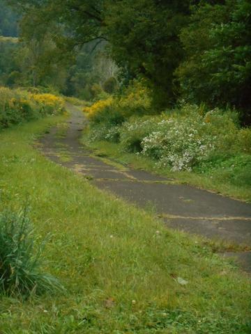
Lambs Creek Hike and Bike Trail is an asphalt trail following the route of the former Erie Lackawana Rail line from Mansfield to the boat launch area in the Lambs Creek Recreation Area. The trail is mostly level. It passes over the steep sides of the dike just south of Mansfield. Some parts of the trail are near the river and/or in the flood plain of the Tioga Lake. The trail may be flooded and impassible in these areas if heavy rains have resulted in the closing of the gates on the dam. Be aware of conditions and use caution. Turn around if you encounter high water. The current path of the trail leaves the route of the former railroad to go around an impassible area around an old pond, once called Clark's Pond. Here the trail follows the roadway that was once part of the Lambs Creek Village before the flood of 1972 and the building of the dam. The trail rejoins the former railway on the N. end of the former village and continues to the northern terminus near the boat launch. There trail will pass the old bridge over the Tioga River that has been dubbed graffiti bridge. The bridge is officially closed and not maintained by the USACE and is blocked by a bar across both ends. If you decide to take a look at the bridge, be aware that much of the graffiti contains foul language and sexual innuendo.
Features
Restrooms on site
Content from Official Website, Ives Run Recreation Area Trail USACE Trail Map, Lambs Creek Hike&Bike Trail on TrailLink, and Mid State Trail website
Last updated March 13, 2024