Sunkhaze Meadows National Wildlife Refuge


Sunkhaze Meadows National Wildlife Refuge
Milford, Maine 04461
Official WebsiteSunkhaze Meadows National Wildlife Refuge interactive map
Sunkhaze Meadows National Wildlife Refuge map
Tips for Birding
When submitting eBird observations at Sunkhaze Meadows National Wildlife Refuge, it is most helpful to start a new checklist for each hotspot within the refuge. Use the general hotspot when you have a checklist that includes multiple locations or if no other hotspot or personal location is appropriate for your sightings.
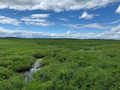
About this Location
The Sunkhaze Meadows National Wildlife Refuge (NWR) supports an expansive, intact peat bog system. The free flowing Sunkhaze Stream and its tributaries meander through diverse habitats including raised peat domes, grassy wet meadows, and floodplain forests before joining the restored Penobscot River. Mature upland forests surround the wetlands, protecting this unspoiled landscape for future generations of plants, animals, and people.
There are three units that comprise Sunkhaze Meadows National Wildlife Refuge: the Sunkhaze Meadows Unit (11,485 acres), the Benton Unit (334 acres) and the Sandy Stream Unit (58 acres).
- The Sunkhaze Meadows Unit is located about 14 miles northeast of Bangor, about 3 miles east of the Penobscot River. The property is bounded on the south and east by a county road, on the north and east by Stud Mill Road and on the west by a railroad line.
- The Benton Unit is about 5 miles northeast of Waterville in the town of Benton. The property is just east of the Sebasticook River, bounded on the west by ME-139, on the south by Albion road and on the east by Fowler Brook.
- The Sandy Stream Unit is in Unity, bounded on the south by ME-139 and by town-owned land, on the west by Prairie Road and on the east by Sandy Stream as it flows north to Unity Pond.
Features
Restrooms on site
Content from Official Website
Last updated October 5, 2023
 United States Fish & Wildlife Service