Bronson Hill Conservation Area
Bronson Hill Conservation Area
Sugar Hill, New Hampshire 03586
Official WebsiteBronson Hill Conservation Area map
About this Location
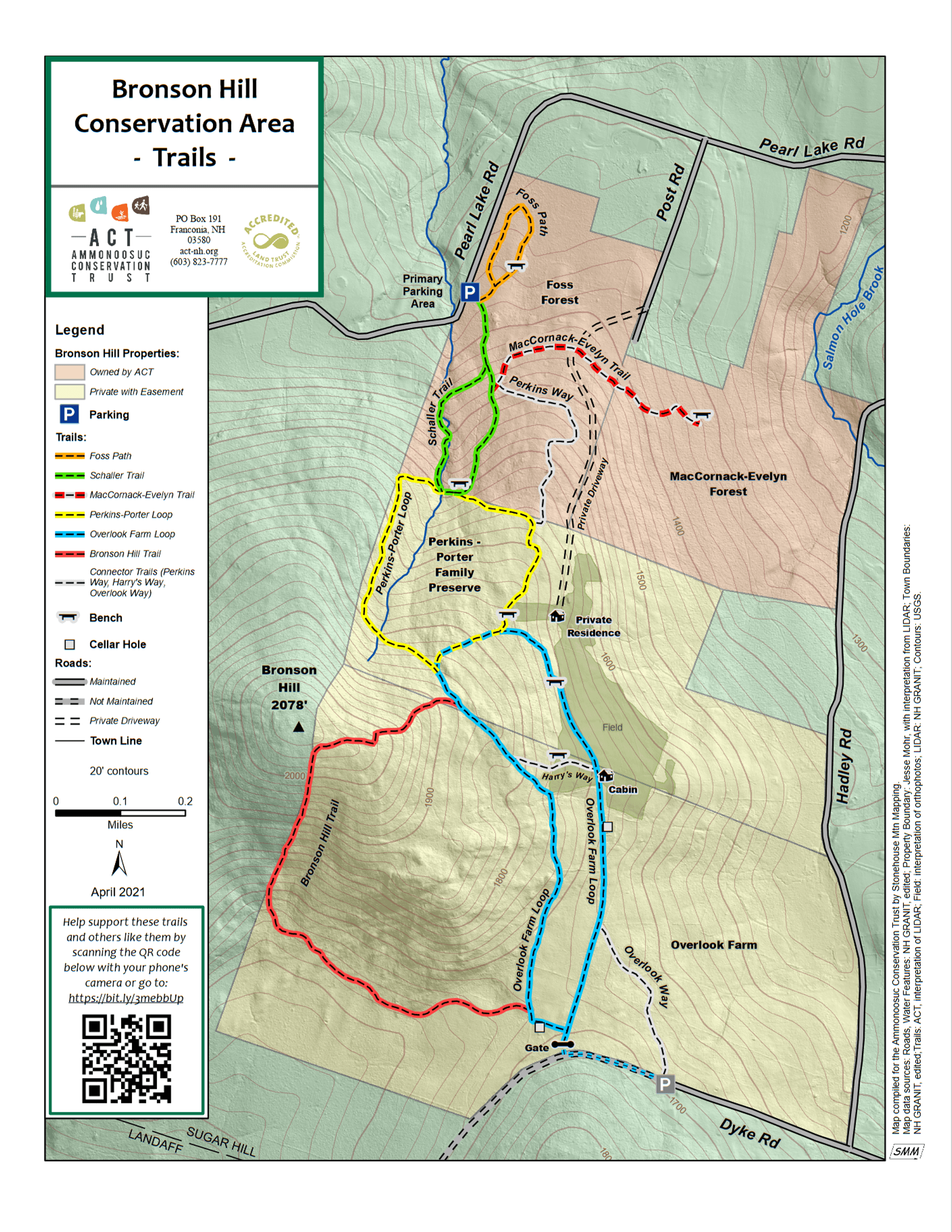
The Bronson Hill Conservation Area covers over 600 acres and is made up of 4 properties. Foss Forest and MacCornack-Evelyn Forest are both owned by the Ammonoosuc Conservation Trust (ACT); the Perkins-Porter Family Preserve and Overlook Farm are both privately owned with a conservation easement held by ACT.
There are many trails and old logging roads that crisscross the Bronson Hill Conservation Area. Nine of these trails have been marked with trailblazes and are being maintained by ACT volunteers. The public is welcome to hike, snowshoe, and cross-country ski any of these marked routes (as well as the unmarked routes in the Conservation Area) but should be respectful of the space around the landowners’ homes. The entire trail system can be accessed from Pearl Lake Road where there is a small parking area, please carpool whenever possible.
Notable Trails
Overlook Farm Loop—easy to moderate; 1.6 miles long; about 220 ft. elevation gain; blue blazes
Named after the farm once on this property, the Overlook Farm Loop leads to a cabin and an open field with sweeping views of the White Mountains. The western side of the loop is a snowmobile trail, so you may encounter snowmobilers on the trail in the winter. Also, in addition to ACT’s blue trail blazes, you will see orange blazes and arrows mounted by the snowmobile club. (NOTE: On the eastern side of the loop, as you walk north from the cabin, you are in an open field. Follow the path north across the field, and turn left at a blue arrow towards the bench. The Overlook Farm Loop continues into the woods behind the bench.)
Perkins-Porter Loop—moderate; 1 mile long; about 240 ft. elevation gain; yellow blazes
Named after the Perkins and Porter families whose generosity helped create the Bronson Hill Conservation Area. The western side of the loop is a snowmobile trail, so you may encounter snowmobilers on the trail in the winter.
Bronson Hill Trail—moderate to difficult; 1 mile long; about 430 ft. elevation gain; red blazes
This trail ascends Bronson Hill with one very steep section on the southern side of the hill that some hikers may find challenging.
Schaller Trail—moderate; 0.8 miles long; about 220 ft. elevation gain; green blazes
This trail is named after Carl Schaller, a long-time ACT member and rector of All Saints Episcopal Church in Littleton.
Foss Path—easy; 0.4 miles long; about 40 ft. elevation gain; orange blazes
The easiest trail in the Bronson Hill Conservation Area, Foss Path is a good option for someone wanting a short, easy hike.
MacCornack-Evelyn Trail—moderate; 0.4 miles long; about 170 ft. elevation gain; red/white blazes
This trail leads from the Schaller Trail into the MacCornack-Evelyn Forest and is a lovely ramble through the forest to a bench.
Harry’s Way—0.1 miles long; white blazes
Named after Harry Reid, one of ACT’s founders and original board members, this trail connects the eastern and western sides of the Overlook Farm Loop and makes it possible to do a shorter version of this loop.
Perkins Way—0.4 miles long; white blazes
This trail is a less steep way to get from the Schaller Trail to the Perkins-Porter Loop.
Overlook Way—0.3 miles long; white blazes
This trail runs from the Dyke Road parking area to the Overlook Farm Loop.
Occasionally, in the Overlook Farm portion of the Conservation Area, you may notice brown trail signs hanging from the trees. These were mounted by a previous owner of the property and should be disregarded.
Content from Official Website
Last updated November 9, 2023