
Clear Creek Metro Park
Clear Creek Metro Park
185 Clear Creek Road Rockbridge, Ohio 43149
Official WebsiteClear Creek Metro Park webpage
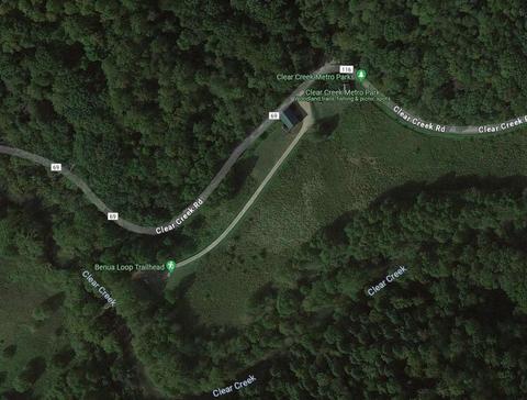
Clear Creek Metro Park map
Tips for Birding
The Fairfield-Hocking county line runs through Clear Creek Metro Park. (See the map for the location of the county line.) eBird hotspots are organized by county. If you carefully keep your bird records by county, be sure to use the specific hotspots in this park so that the birds will be assigned to the proper county.
Clear Creek Metro Park is an approximately 5,000-acre natural area park located in Hocking and Fairfield Counties. Its proximate location to the glacial boundaries of both the Wisconsinan and Illinoisan Glaciers and the unglaciated portion of Ohio as well as the pre-glacial Teays River has resulted in a unique and diverse area. Clear Creek Metro Park is Ohio’s largest dedicated natural area and has been recognized by Ohio Audubon as an Important Bird Area.
Over 2,200 species of plants and animals have been documented in this area including 800 species of plants, over 160 birds, nearly 80 species of butterflies, and over 1,200 species of moths. Nearly 40 species of plants and animals found on Ohio’s rare and endangered species list have been found within the park boundary. For birdwatchers, Clear Creek represents one of the premier places in Ohio to observe breeding warblers with 18-20 species present annually. Over 100 species of birds can be found nesting in the Clear Creek Valley each summer.
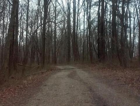
Many of the rarer breeding species are associated with the hemlock-hardwood forested ravines, which can be accessed along the Hemlock Trail, Fern Trail, and areas along Clear Creek Road. Approximately 14 miles of hiking trails provide access to the north side of the park. High-quality birding can be enjoyed from Clear Creek Road, but this is a public roadway and one should exercise caution and courtesy to vehicles if one chooses to bird from the roadways. Peak spring migration occurs the last week of April and the first week of May in a typical year. During the winter, evening grosbeaks may be seen and heard flying across Clear Creek from ridgetop to ridgetop looking for feeders on adjacent private property.
Please carefully read the signs at trailheads for length, times, and trail difficulty. Easy hiking trails occur along Clear Creek and at the Hambleton-Barnebey Day Use area. During the spring and early summer, check the pines in the Hambleton-Barnebey Day Use area for breeding pine and prairie warblers. A checklist of the birds of Clear Creek may be obtained from park staff, at bulletin boards, or by contacting the Columbus and Franklin County Metro Parks.
From I-270, take US-33 east toward Lancaster. Go south past Carroll and stay on the bypass. Pass the stoplight at Sugar Grove and go about one mile to Clear Creek Road (CR-116). Turn right on Clear Creek Road (Sunoco Gas Station on the corner). Picnic areas, facilities, and trails are located along Clear Creek Road for the next seven miles.
Open year-round from dawn to dusk; closed the first four days of annual deer gun season for a controlled deer hunt. Birding and hiking along Clear Creek Road and the 14-mile trail system.
Parking Areas: Pull-offs along Clear Creek Road; Creekside Meadows Picnic Area, Fern Trail Picnic Area; Hambleton-Barnebey Day Use Area; Starner House Park Office.
The Hemlock Trail located along Clear Creek Road .5 miles west of Camp Wyandot, operated by Camp Fire USA, annually has breeding Canada Warblers, Hermit Thrushes, Veeries, and occasionally Magnolia Warblers and Blue-headed Vireos. Expect to find 12 species of breeding warblers along the lower end of this trail from Clear Creek Road to the third bridge before the trail becomes steep and difficult. Please read signs at the trailhead and allow time for hiking, some of the trail areas are moderate to difficult hiking. Birding programs are offered by a park naturalist, please check the Parkscope program schedule or website for dates and times.
Birds of Interest
Winter
Woodland-resident songbirds; Black Vulture, Evening Grosbeaks.
Spring
Typical woodland migrants; warblers.
Summer
Nearly 20 species of breeding warblers; Hermit Thrush, Veery, Red-shouldered Hawks, and over 100 nesting species of birds annually.
Fall
Typical woodland migrants.
About this Location
Clear Creek Valley is one of the most pristine and secluded natural areas in Central Ohio. Variations of land surfaces, soils and climates have produced a medley of habitats that harbor more than 800 plant species and 150 species of birds, many of them rare.
You may catch a glimpse of turkey, deer, ruffed grouse, coyote, black vultures, or even see the traces of the elusive bobcat along the park’s 12 miles of trails.
Centuries of glacial flooding have cut the valley through the Black Hand sandstone leaving an array of scenic cliffs and rugged rock formations overlooking the creek.
Oak and hickory forests interspersed with giant hemlocks and ferns, along with the last remaining Ohio colonies of rhododendron, provide the perfect backdrop or a getaway from city life.
Notable Trails
Clear Creek Lake Trail
Clear Creek Metropark in Rockbridge offers some of the most advanced and rewarding hiking trails. With over twelve miles worth of options that twist, zig-zag, and ascend, Clear Creek offers a variety of terrain. The Lake Trail is one of the best, especially in autumn. The Lake Trail is .9 miles worth of moderate-to-difficult hiking on a dirt path that winds through the woods to a fabulous observation deck overlooking the beautiful Lake Ramona.
The Lake Trail can be accessed from either the Ironwood or Valley View picnic areas, each of which has parking lots. A small portion of Lake Ramona is visible from the observation deck. More of the lake is visible from a trail going north from the main park road.
The Lake Trail, 0.9 mile, is a moderate to difficult hike on a dirt surface. The trail winds through the woods to an observation deck overlooking Lake Ramona. You can make a circuit hike by walking between the two picnic areas on the Chestnut Trail and park roads.
Other trails at Clear Creek Metro Park
Chestnut Trail – 2.2 miles – difficult –hike – dirt and gravel
Goes through valleys with sandstone formations and crosses forested ridges.
Creekside Meadows Trail – 1.7 miles – easy – hike/pets – grass
Follows the banks of Clear Creek through open fields. A 1-mile section of the trail west of Starner Road to the Fern Picnic Area is also a pet trail.
Good Prairie Trail – 0.3 miles – easy – hike – grass
Loops around a prairie.
Prairie Warbler Trail – 0.6 miles – easy to moderate – hike – dirt
Crosses a rolling hilltop, goes around a meadow, and through the woods.
Tulip Tree Trail – 0.6 miles – moderate to difficult – hike – dirt
Loops through the woods along a rolling hillside.
Features
Restrooms on site
Content from Clear Creek Metro Park webpage, 10 Best Hikes in Ohio (RootsRated), and Ohio Ornithological Society
Last updated April 26, 2024