Bosque del Apache NWR--Boardwalk Lagoon
Bosque del Apache NWR--Boardwalk Lagoon
San Antonio, New Mexico 87832
Bosque del Apache National Wildlife Refuge websiteFriends of Bosque del Apache NWR website
Bosque del Apache NWR Important Bird Area (Audubon) website
Habitat! Guide to Bosque del Apache NWR booklet
Bosque del Apache National Wildlife Refuge map
Tips for Birding
Bosque del Apache’s Boardwalk Lagoon is one of the top 25 eBird hotspots in New Mexico, with 250 species having been reported here. A parking area for the hotspot is located on the west side of the South Tour Loop road, two miles from the crossroads just east of the Auto Tour Loop entrance fee station. Two-way traffic ends at this parking area; further traffic south is one-way. A portion of the parking area is reserved for vehicles with ADA plates/placards; most, though not all, of the hotspot area is wheelchair accessible.
The Boardwalk Lagoon is a hotspot specific to a limited geographic area within the refuge. eBirders wishing to reduce their number of lists, and not interested in keeping more precise track of where listed birds were observed, may include sightings at the Boardwalk Lagoon either within a South Tour Loop list or an overall list for Bosque del Apache NWR. To facilitate research and communication, do not dump all of your refuge or South Loop sightings into a list for the Boardwalk.
You may think of the hotspot as containing six component areas. Those where you birded or observed a specific individual can be recorded in “Checklist Comments” or in the “Details” section associated with the species. This could be especially valuable should a component area be, in the future, split from the Boardwalk Lagoon as a separate hotspot.
First, immediately to the west of the parking area, a small east-west bridge passes over the Elmendorf Ditch. Viewing of the ditch from either the South Tour Loop or the Elmendorf Trail is typically obscured by willow, reed, and kochia, so the bridge is a good spot to glass the ditch both north and south.
West of the bridge, before entering the boardwalk itself, a right turn would place you on the Elmendorf Trail, extending along the west side of the ditch all the way north to the Tour Loop entrance, coming out just west of the information kiosk there. Although observations along its entire length would not be appropriate for a Boardwalk Lagoon eBird list, observations north into cattails marking that end of the lagoon conventionally are included. Without a spotting scope, it can be difficult to identify species from the boardwalk at this far end of the lagoon; however, there are normally a few “windows” through the vegetation between the east side of the lagoon and the trail which allow closer viewing. Birds in the willow, reed, and kochia lining the ditch, and those on the ditch water, flush easily, so birders must be alert if they are to make a visual identification.
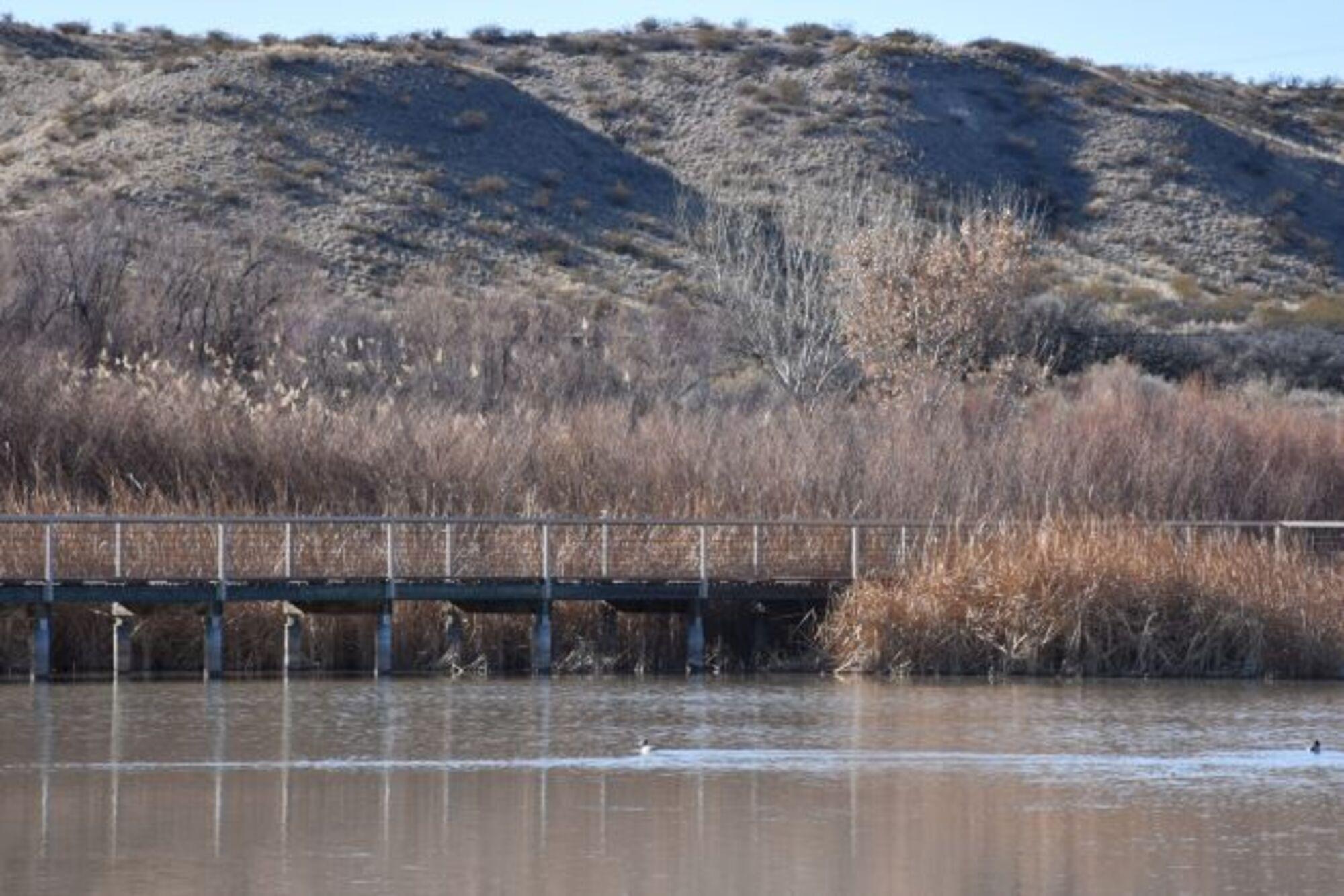
If, after crossing the bridge, you continue west instead of turning north onto the Elmendorf Trail or south onto the Marsh Overlook Trail, you will find yourself on a quarter-mile-long boardwalk crossing the south end of the lagoon. The lagoon is a permanent wetland; it generally has some water year-round. During winter and early spring, it is the deepest water on the refuge, attracting diving birds, and looks like a lake surrounded by cattails advancing into the water. As the weather warms, the water level drops, exposing mudflats favored by shorebirds. With lower water levels, where the boardwalk passes over cattails, birders should be on the lookout for Sora and Virginia Rail. Seasonally, the boardwalk may offer the best chance of seeing American White Pelican and Belted Kingfisher on the refuge.
At the west end of the boardwalk, the Sparrow Loop climbs into the four-wing saltbush and mesquite above the lagoon. This half-mile-long sandy trail offers a chance to spot not only sparrows but Gambel’s Quail and other Chihuahuan Desert species.
The 1.5-mile, relatively flat, Marsh Overlook Trail loop begins south and west of the bridge over the Elmendorf Ditch. Pick up a trail guide at the trailhead. The first bullet point on the current trail guide recommends in bold letters the use of insect repellent spring through fall. This is an interpretive trail, so lettered entries in the trail guide correspond to lettered markers (upright stakes) along the trail, sequenced for counter-clockwise navigation of the loop. These trail markers can serve as references for individual species’ “Details” entries in your eBird lists. The trail encircles wetlands fed by underground water rather than by the ditches used to manage most of the refuge wetlands. Seasonally, standing water is present, but any small areas of open water that may exist are not visible from the trail. There are few “windows” through the cattails and willows lining the interior side of the trail. A good overall view of the wetland, albeit at quite a distance, is available on the west segment of the trail after (proceeding counter-clockwise) you have passed through the initial section closed in on both sides by willow, common reed, desert broom, cottonwood, and tamarisk. As you turn east, you have the option of taking an initially steep quarter-mile round-trip spur trail to the top of a creosote and chamisa-covered bluff or ridge overlooking the marsh; from this vantage point, the wetland appears to be a sea of cattails. The bluffs or bajada ridges close in on the south side of the east-west oriented trail segment with willow and cattail coming up to the north edge of the trail along this portion. The return north to your starting point is walled by willow, cattail, and kochia on the marsh side and by willow and kochia on the ditch side. Seasonally, the west portion of the trail may offer Northern Flicker, Ladder-backed Woodpecker, Hairy Woodpecker, and Downy Woodpecker, whereas Dark-eyed Junco and Spotted Towhee are more common along the south and east portions. Be alert for Bewick’s Wren among the ditch willow, with lucky birders sometimes catching a glimpse of Wilson’s Snipe. White-crowned Sparrow can seem ubiquitous.
Finally, before advancing much further on the Tour Loop, take a few minutes to examine the trees, shrubs, and winter-flooded area on the east side of NM- 1 directly across from the Boardwalk parking area. Often, the view of the latter is blocked by thick vegetation. A short walk south will bring you to an east-west restricted-access road topping the berm forming the south end of that wetland, separating the field from a parallel east-west ditch flowing into the Elmendorf. From this intersection, you are more likely to be able to view the field; the feeder ditch has been known to be frequented by waterfowl, including Neotropic Cormorant.
Please observe all signage and barriers. Areas are restricted to provide undisturbed roosting and foraging by wildlife, as well as for your safety given that refuge staff may be flooding fields or operating heavy equipment.
The Boardwalk Trail is open daily from one hour before sunrise until one hour after sunset. The trail is 0.5 miles roundtrip (level of difficulty: easy).
Journey through cattails without maneuvering through the water. The habitat is a semi-permanent wetland with open water and cattails. Seasonally, search for marsh wren, green heron, yellow-headed blackbird, western grebe, least bittern, northern rough-winged swallow, muskrat, and western painted turtle.
The trailhead and parking lot are located along the South Loop (the Marsh Overlook Trail is found at this trailhead too!).
About Bosque del Apache National Wildlife Refuge
See all hotspots at Bosque del Apache National Wildlife Refuge
Established in 1939 to provide a critical stopover for migrating waterfowl, the refuge is well known for the thousands of sandhill cranes, geese, and other waterfowl that winter here each year.
Situated between the Chupadera Mountains to the west and the San Pascual Mountains to the east, the 57,331-acre refuge harbors a wild stretch of the Rio Grande, a ribbon of cottonwood and willow trees visible on the landscape from distant mesas.
Petroglyphs tell the story of ancient people who lived and hunted here. The river and its diversity of wildlife have drawn humans to this area for at least 11,000 years when humans migrated along this corridor, sometimes settling to hunt, fish, and farm. Artifacts and stone tools found nearby tell us that nomadic Paleo-Indian hunters pursued herds of mammoth and bison in the valley.
Today, Bosque del Apache is part of the National Wildlife Refuge System, a national network of lands and waters set aside and managed for the benefit of wildlife, habitat, and you.
Features
Wheelchair accessible trail
Entrance fee
Roadside viewing
Restrooms on site
Content from Bosque del Apache National Wildlife Refuge website, Birding in New Mexico (National Audubon Society), and John Montgomery
Last updated March 10, 2024
