Horse Hill Nature Preserve, Merrimack
Horse Hill Nature Preserve, Merrimack
Merrimack, New Hampshire 03054
Official WebsiteHorse Hill Nature Preserve brochure and map
Tips for Birding
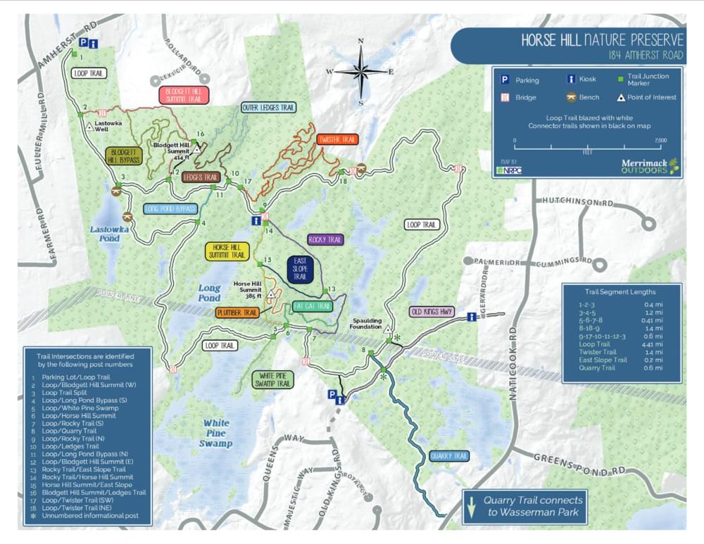
Horse Hill Nature Preserve is a large 565-acre tract containing upland woods, beaver dam ponds, marshes, streams, and a power line right-of-way. Many trails, some of which are old roads and may have wet spots in spring and after heavy rains. The pond along the trail from the parking area and the White Pine Swamp and adjacent trails near the power line are the most productive areas. The preserve has been managed by the Merrimack Conservation Commission since the spring of 2007. Access to parking is available on both sides of the area, the trails have been marked and all junctions are signed. Distances are indicated.
The preserve is located on Amherst Road, Merrimack. From the F.E. Everett Turnpike exit 11 in Merrimack (Continental Boulevard), exit west and make an immediate right onto Amherst Road. Follow Amherst for 2.75-3.0 miles to just past Lester Road. On the left will be a large Horse Hill Nature Preserve sign and a parking area. A kiosk includes information on the 560-acre site and provides trail maps. The main trailhead begins here at the upper left corner of the rough trail map posted on Merrimack’s website. Additional parking areas are on Gehard Drive, off Naticook Road, and at the Watanic Bowmen facility.
Birds of Interest
Spring/summer/fall birding. Hunting is permitted. Waterfowl on the various ponds: Canada Goose, Hooded & Red-breasted Merganser. Several nests in a Great Blue Heron rookery. American Woodcock, Yellow-rumped and Palm Warblers, Field Sparrow, typical forest and feeder birds.
About this Location
In April of 2002, the Town of Merrimack voted to purchase the property now known as the Horse Hill Nature Preserve. Due to its size, quantity of wetlands, and impact on wildlife and water resources, this property was listed as the top priority for conservation in the 2002 Town of Merrimack Master Plan.
The 563± acre property consists of gently rolling to fairly steep terrain and two hills approximately 400′ elevation. The land was cleared for pasture many years ago, it has been logged several times, and now consists primarily of mixed hardwood forest with trees between 20 and 60 years of age. The property includes a series of streams, ponds, swamps, and numerous wetlands totaling approximately 60 acres. The varied terrain, habitat, and large areas of undisturbed open space have encouraged a wide variety of wildlife to thrive on the property.
A power line easement traverses the property, creating a shrubland undergrowth area. A small sandpit was created by previous owners, but sand has not been removed for several years.
Old logging roads form the basis of what is today a trail network used by hikers, bikers, hunters, snowmobilers, horseback riders, etc. This trail network covers the majority of the property, however, there are still large areas without defined access.
Horse Hill is the largest preserved open space property in the Town of Merrimack and wide range of opportunities for both passive and active recreation as well as diverse habitats for plants and wildlife.
The Preserve takes its name from Horse Hill, one of two 400′ hills located within the Preserve. Blodgett Hill, the highest point within the Preserve, is named for the Blodgett family who were early settlers of this part of Merrimack. The Spalding family were also early settlers, and the foundation of the house of Captain Spalding is located in the Preserve. Numerous stone walls still mark the one-time farming activities of these two families. Two hand-dug, stone-lined, wells are located on the property. One of these wells is still in use today. A well-preserved portion of Old Kings Highway, a Colonial road that once ran from Keene to Portsmouth, crosses the southeast corner of the Preserve.
Notable Trails
The AllTrails website has a description and map of a hike at Horse Hill Nature Preserve.
Features
Restrooms on site
Wheelchair accessible trail
Entrance fee
Content from Official Website
Last updated October 21, 2023