Lake La Su An Wildlife Area
Lake La Su An Wildlife Area
9455 County Road R Pioneer, Ohio 43554
Lake La Su An Wildlife Area Official WebsiteLake La Su An Wildlife Area map
Also, see all the hotspots at:
La Su An Important Bird Area
Williams County Birding Drive
Tips for Birding
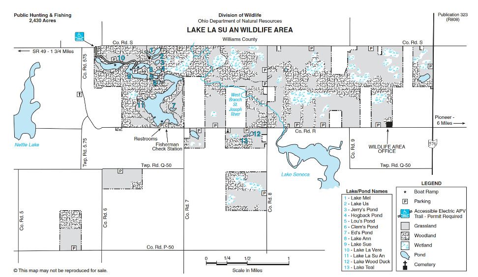
In a county not known for its birding, this 2,200-acre wildlife area offers a variety of appealing habitats, including a riparian corridor along the St. Joseph River, 13 lakes and ponds, tracts of mature oak-hickory ridges, bottomland hardwoods, as well as upland fields. The result is an avian oasis in a mostly barren county. The best place to start birding Lake La Su An is at the fisherman’s check station located on the south end of Lake La Su An itself on County Road R. If you have the time, hike the gravel service road that starts here at the check station and goes around the lake (this hike is a couple of miles long). This walk around the lake can be particularly rewarding during spring migration and the breeding season.
There’s a lot more to be seen at Lake La Su An, much of which can be birded through a 6.4-mile driving tour with frequent stops. This trip goes through several different habitat areas, including upland fields and wooded areas, and offers the possibility of finding species not generally seen by hiking around the lake. To take this tour, turn right from the parking lot at the check station and head west on County Road R. After one mile, the road will become County Road 5.75. The road ends after 1.8 miles; turn right here onto County Road S. At the 2.1-mile mark, where the pavement ends, there’s a small swamp on the right that can be checked. At the 3.0-mile mark of the tour, there’s a parking lot on the right side of the road. If you have time, it is worthwhile to park your car here and continue walking for a while down County Road S. It’s good to remember that the property on the north side of the road is a boy scout camp and you need permission to enter. Everything on the south side of the road is part of the wildlife area. At the 3.1-mile mark, the road passes over the Saint Joseph River. This is an excellent place to watch and listen. The entrance to the boy scout camp is at the 3.4-mile mark and just past that on the left is another small swamp, easily visible from the road. County Road S intersects with County Road 8 at the 3.6-mile mark. You’ll want to turn right onto County Road 8, but be sure to check out the field on the southeast corner of this intersection. After turning right onto County Road 8, continue to County Road R and turn right. You’ll pass more open fields as you return to the parking lot at the fisherman’s check station. At the 6.4-mile mark, you’ll be back at the check station.
From Toledo, take the Ohio Turnpike west about 50 miles to the OH-15 exit. Head north on SR 15 for less than a mile and turn left (west) onto OH-20A. Continue west when OH-20A merges with US-20. Turn right (north) on Williams County Road 7 and follow it until it ends at County Road R. Turn left (west) and proceed less than a half-mile to the parking lot on the right side of the road.
The main parking area is at the angler’s check station on County Road. R. There are other clearly-marked parking areas throughout the wildlife area.
Birds of Interest
Winter
Long-eared owl, Northern Shrike, Northern Harrier.
Spring
Migrating warblers and other songbirds. All of the eastern warblers have been seen here during migration (except for Swainson’s of course).
Summer
Henslow’s Sparrow, Prothonotary Warbler, Hooded Warbler, Brewster’s Warbler, Kentucky Warbler (rare), Cerulean Warbler, White-eyed Vireo, Least Flycatcher, Bobolink, Sedge Wren (rare), Summer Tanager (rare), King Rail (rare), Sandhill Crane.
Fall
Migrating ducks and songbirds.
About Lake La Su An Wildlife Area
See all hotspots at Lake La Su An Wildlife Area
The 2,430-acre area lies in Bridgewater and Northwest townships in the northwest corner of Williams County.
Williams County Road R provides access to the area from OH-576. The area can also be reached by Williams County Road 7 from US-20.
Lake La Su An Wildlife Area is on the Wabash end moraine deposited during the Wisconsin glaciation. Originally, the area was a beech-maple hardwood forest containing beech, white ash, white oak, red oak, and sugar maple. This combination of hardwood species still dominates the area. There are also several lowland areas that are poorly drained, forming wooded wetlands. Index of Ohio’s trees from the Division of Forestry.
The wildlife area is moderately to gently sloping with natural drainage to the West Branch of the St. Joseph River which cuts through the middle of the area. Approximately two-thirds of the wildlife area is in woods and brushland. The other one-third is divided between cropland and meadow. The water areas include 14 lakes and ponds ranging from 1/4 acre to 82 acres, over 30 wooded wetlands, and restored wetlands from two to 18 acres.
The purchase of land for this wildlife area began in 1981. Additional land is being acquired as funds become available. Land posted with yellow wildlife area signs is part of Lake La Su An Wildlife Area.
Wildlife management activities include the development and management of grain crops and grassland. Trees and shrubs have been planted along field borders and in odd areas to provide permanent cover for upland wildlife. Woods have been protected and improved and most former crop fields have been returned to meadows to prevent soil erosion on the steeper slopes.
Prior to the Division of Wildlife acquisition, an unexploited fishery had resulted in high-quality largemouth bass and bluegill populations in many of the lakes and ponds. To maintain the quality under public fishing pressure, special management techniques and regulations are being used.
Features
Restrooms on site
Roadside viewing
Content from Lake La Su An Wildlife Area Official Website and Ohio Ornithological Society