UCSB North Campus Open Space (formerly Ocean Meadows Golf Course)
UCSB North Campus Open Space (formerly Ocean Meadows Golf Course)
Goleta, California
Coal Oil Point ReserveNorth Campus Open Space
Tips for Birding
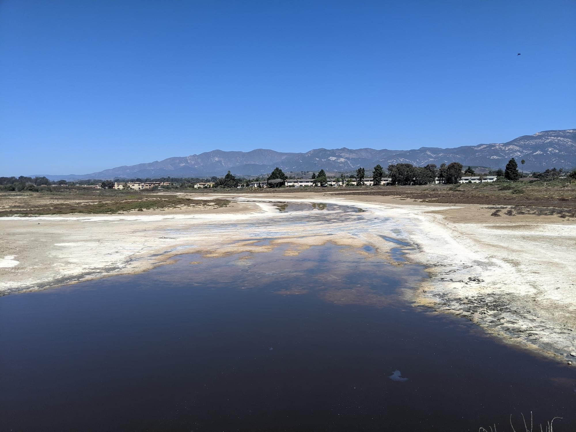
Late fall, winter, and early spring are the best seasons for birding at North Campus Open Space (NCOS). Due to the lack of rainfall in recent years, late spring, summer, and early fall can result in little or no water in the main channels resulting in a desolate landscape and almost no water birds. However, regardless of the season, NCOS is always a good place to find other common local species and there is always the chance of discovering something uncommon or rare here.
Two of the hottest spots for birding at NCOS, even in summer, are the marshy habitats at Whittier Pond and beneath the Phelps Creek Bridge where Phelps Creek empties into Devereux Creek. The two northwest ponds are also good for waterbirds when they have water in the winter and spring.
If you have limited time or just prefer an easy walk, head west along the northern Marsh Trail (see below) at least to the Phelps Creek Bridge.
A special request for eBirders: Since NCOS is a major restoration project, eBird checklists are important for understanding what bird species utilize this habitat and when during the year. Thus, if you are birding through NCOS on the way to other places (like Devereux Slough or the beach), please use a separate checklist for the NCOS portion, and only report birds encountered from within the NCOS boundaries. This means that you can count birds seen or heard outside the boundaries if you are on walking on any NCOS trail or road. However, please don’t set up your scope on the Venoco Road bridge over the channel and count all the birds in Devereux Slough to pad your NCOS list.
Birds of Interest
With lots of water in the two main channels in December and January, NCOS is often teeming with waterfowl with up to 17 species of ducks (potentially including Eurasian Wigeon) and up to 6 species of geese: Snow, Ross’s, Greater White-fronted, Cackling, and Canada (all best seen early in the mornings, and late in the afternoon, and possibly around noon when they are not out foraging in other places). Hooded and Red-breasted Mergansers can sometimes be seen.
Soras, and less frequently, Virginia’s Rails, can be found at the Phelps Creek Bridge in fall, winter, and spring.
Up to 21 species of shorebirds can be seen here as spring and fall migrants and as wintering birds. Red-necked Phalaropes can be seen northbound in April and May and southbound in late June through early November. Less frequently, Baird’s and Pectoral Sandpipers can be seen in September and October. Snowy Plover has bred on the mudflats at least once.
Most of the heron family is easily seen here, and more rarely, Cattle Egrets and American Bittern.
Though abundance varies greatly from year to year, White-tailed Kites can occasionally be seen at NCOS year-round.
In recent years, Tropical Kingbirds have regularly been seen at various spots around NCOS, and especially at Whittier Pond, from late September through February. Western Kingbirds can be seen in summer and have bred in the Eucalyptus Row.
Cliff Swallows breed here in large numbers from late March through August and can be seen collecting mud in the northwest ponds and flying up to their nests under the eves of the houses just north of the ponds.
Small flocks of Scaly-breasted Munias, a naturalized exotic species, can typically be seen year-round at Whittier Pond and at the Phelps Creek Bridge.
Lark Sparrows can often be encountered year-round along the paved road up the hill, and the Eucalyptus Row. The state listed Belding's Savannah Sparrow breeds secretively in pickleweed saltmarsh (Salicornia sp.) along the edges of the water - note that other Savannah Sparrow subspecies are present during the winter, but in summer Belding's is the only expected subspecies.
About this Location
The main entrance and parking lot for NCOS is just west of Storke Road on Whittier Drive, and the hours are from dawn to dusk. The Visitor Plaza beside the parking lot has a lot of informative signs about this special place.
Be aware that many others besides birders enjoy this location including nearby residents, students, university staff, and many doggies taking their owners for a walk. Thus, there can be many walkers, joggers, and bicyclists using the main trails on the north, east and south sides of NCOS for recreation and commuting to work and school, so bird from the edge of the trail and always be ready to step aside. Also note that NCOS is an extensive and long-term restoration project and there are sensitive plants and habitats throughout the property, so please stay on the trails.
About Devereux Slough Complex
See all hotspots at Devereux Slough Complex
Devereux Slough was once a larger and deeper estuarine wetland covering much of COPR and NCOS, with a permanent channel connected to Goleta Slough through what is now Isla Vista. It is fed by inputs from Devereux Creek (flowing through the Eucalyptus line in Ellwood Mesa), Phelps Creek (from the north, in the "North Parcel" restoration area), Whittier Channel (just west of the Whittier Parking Lot), and an eastern unnamed tributary.
In the 1861 water year, overgrazing combined with massive rainfall led to enormous sediment deposits in the Slough and turned it from a deep estuary into a salt marsh. During the 1960s, the northern portion of the Slough was artificially filled in to build Ocean Meadows Golf Coarse, which closed in 2013.
Now, the Slough alternates between tidal saltwater and pooling fresh or brackish water depending on the season. During most of the year, a sand berm where the Slough connects to Sands Beach prevents water from flowing into or out of the Slough. As the Slough fills with water during winter rains, it eventually breaks through the berm and empties into the ocean. For a period of several weeks it becomes tidal until the berm is reformed. From that point on, the Slough continues to fill until either it breaches again, or the rain stops for summer. During summer, the water in the Slough gradually evaporates, which causes the channel to become narrower and more saline. The process then repeats when winter rains return.
The southern portion of the Slough was named Coal Oil Point Reserve and incorporated into the University of California Natural Reserve System in 1970. Numerous University of California research projects have taken place at COPR over the last five decades. Active weeding programs use teams of volunteers and paid staff to maintain the natural grassland and scrub communities.
In 2017, UCSB's Cheadle Center for Biodiversity and Ecological Restoration purchased the former golf course to create a restoration site now known as North Campus Open Space. Restoration began in 2017 with substantial ground-moving efforts designed to produce salt marsh habitat that will be resilient to sea level change. The project is now nearing completion, and active restoration work on site will likely gradually slow over time.
Free parking is available for NCOS off of Whittier (34.4222, -119.8713). Parking is also available on COPR at (34.410822, -119.876781), but requires a UCSB parking permit or a day pass (paid at meters on site). Free street parking is available on Camino Majorca in western Isla Vista, which provides foot or bike access to COPR via the West Campus Bluffs Trails. A public portapotty is available by Coal Oil Point at (34.407781, -119.878912)
Notable Trails
The main trails that define the borders of NCOS include the Marsh Trail along the northern and eastern borders, a paved segment of the California Coastal Trail along the southern border (also known previously as Venoco Road), and an unnamed trail along the western border (here referred to as the “Eucalyptus Row Trail”). If you have the time and are up for a 2+ mile walk, this circumnavigation of NCOS can be birded in either direction and will expose you to all the different habitats.
Recently opened in 2022, the Mesa Trail crosses the top of the mesa and gives better access to such grassland species as Western Meadowlark (in winter), Grasshopper Sparrows (a skulking species that is typically hard to see, but will sometimes perch on the fence), Lark Sparrow (a scarce breeding bird on the South Coast of the county) and possibly one or more wintering Burrowing Owls that sometimes use burrows created for them in the two large mounds.
Features
Wheelchair accessible trail
Restrooms on site
Roadside viewing
Content from David Blue, The Past, Present, and Future Hydrology of Devereux Slough, Coal Oil Point Reserve, North Campus Open Space, and Conor McMahon
Last updated October 10, 2023
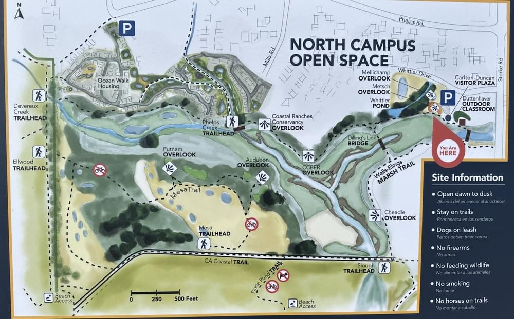 NCOS Trail Map
David Blue
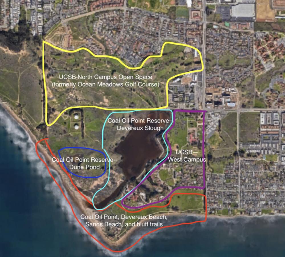 Devereux Slough Complex
Google Maps; Linus Blomqvist