Taylorsville MetroPark
Taylorsville MetroPark
2000 OH-40 Vandalia, Ohio 45377
Official WebsiteTaylorsville MetroPark map
Also, see all the hotspots at:
Dayton Northeast Birding Drive
About this Location
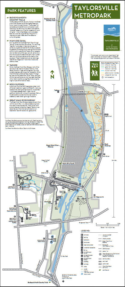
Historic remnants of the Miami-Erie Canal and the once-thriving village of Tadmor mix with scenic forests to provide an interesting experience for both the hiker and bicyclist. In addition, fascinating rock formations with overhangs and small cavitations with calcite ribbons can be found.
Taylorsville MetroPark contains exceptional examples of a mature upland forest with many spring wildflowers, second-growth woodlands, natural succession areas, a few aging pine stands, a few managed grasslands, and extensive floodplain forests along the Great Miami River Corridor.
A section of the Buckeye Trail and the North Country Trail runs through Taylorsville MetroPark.
Notable Trails
Taylorsville MetroPark Trails
White Trail – .3 mile
Green Trail – .4 mile
Violet Trail – .8 mile
Blue Trail – .9 mile
Yellow Blue Trail – 1.2 miles
Orange Trail – 3.2 miles
With more than 8 miles of trail and challenging elevation changes, the trails at Taylorsville MetroPark offer hikers an opportunity to challenge themselves while immersed in an old-growth forest with stunning river overlooks. From the trailhead located just north of the stone shelter, you will find a variety of trail lengths and difficulties to make your experience fit your needs. Carefully choose a trail based on your hiking expectations, and be sure to come back often to explore and experience seasonal changes in this remarkable area.
The Buckeye and North Country Trails join the Great Miami River Bikeway at Old Springfield Road and follow it south through the park.
A description with a map of a 3.2-mile loop hike on the Orange Trail is on the AllTrails website.
Features
Restrooms on site
Wheelchair accessible trail
Content from Official Website