Berlin Mudflats
Berlin Mudflats
Deerfield, Ohio 44411
Berlin Lake Official WebsiteUS Army Corps of Engineers Water Management website
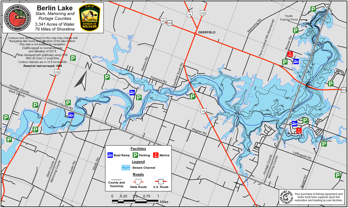
Berlin Lake map
Also, see all the hotspots at:
Berlin Lakes System Important Bird Area
Berlin Lake Birding Drive
Tips for Birding
For those interested in shorebirds, the best areas to find them are the mudflats north and south of the Price Street Bridge. To get to this area, go south about 1 mile from the OH-225 bridge and turn west on Price Street. Cross the bridge and enter the large parking area on your right. From this point, one can see several acres of mudflats when conditions are right. By crossing the roadway and hiking the west shoreline, south of the bridge, you can explore over a hundred acres of mudflats. Further southwest, this area opens up to reveal mudflats that cannot be seen from any road. The mudflat areas, both east and west of the OH-225 bridge, are also choice locations for shore birding. This area has also been a very productive region in recent years. Parking here, though, can be difficult as there is no parking available in the immediate vicinity of the bridge. Parking is permitted, however, if you go beyond the “No Parking” signs and walk back to the bridge area. The US-224 bridge area, later in the season, from late August through November, can also be very rewarding. The best strategy here is to park at the west end of the bridge and walk south along the west shoreline. Here you can walk miles of shoreline/mudflats encountering cove after cove of choice habitat. This area has also been a good area for migrating waterfowl, raptors, and gulls.
About this Location
The mudflats area of Berlin Lake in eastern Stark County along OH-225 north of Alliance can be very productive during fall migration for shorebirds. The following information can help you determine where to check and how to access different areas as the water levels drop. Berlin Lake is a reservoir created by a dam holding back the Mahoning River in order to manage flooding in eastern Ohio. The water levels are controlled by the U.S. Army Corps of Engineers and vary according to rainfall amounts and how much water is being allowed to flow into the Ohio River.
The US Army Corps of Engineers website provides information about the water levels. Look under the Reservoir Conditions heading and go to the Daily Reservoir Summary link for the latest information. Look for Berlin and then at the Pool Elevation number next to it for today’s date. In order for there to be mudflats in the area, the Pool Elevation needs to be at or below 1020 feet above sea level. As that number drops, more and more mudflats develop beginning along Greenbower Street Northeast, then moving north along the river going towards German Church Road on the border of Stark and Portage Counties.
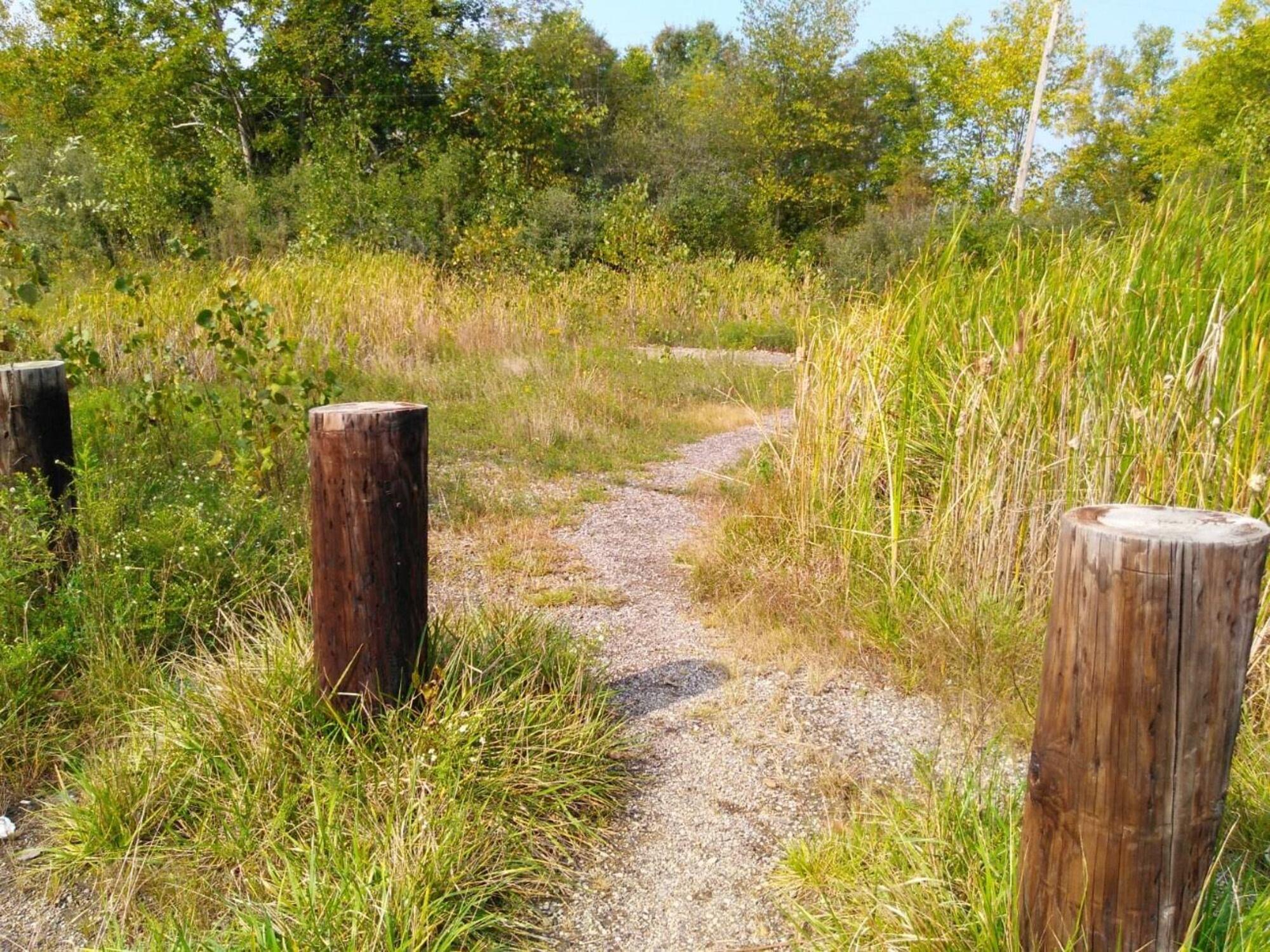
A scope is really a must here, as the birds are often distant and can be easily flushed by too close of an approach. You should also wear appropriate boots and be very wary of walking out into the mud. Many a boot has been lost and more than a few have become stuck in the mud needing assistance to free themselves, and have been covered in mud after the attempt, including their cameras and optics! Bird smart and be safe. Also, some of the access points described below are from narrow, rugged, and steep trails that lead down to the mudflats. Other spots like parking lots are much more accessible.
Early in fall migration season (August) the pool level at 1020’ begins to show areas of mudflats along Greenbower Street Northeast. Access to Greenbower is from OH-225 north of Alliance. Heading west on Greenbower off of OH-225, you will cross a bridge over the Mahoning River. Looking right (north) as you drive you can see through the trees the mudflats area. Parking in this area is very limited, so pay attention to signs. There is a small pull off further west along Greenbower on the right, and then a very small pull off on the left. Again, pay attention to the signs on the north side of the road, as there is a small area of legal parking before signs indicate no parking by private property just before the Mahoning Valley Trail that goes north toward Deer Creek Reservoir. After parking, you walk back east towards the bridge along the road. When you reach the point that you can see mudflats to the north, you will see a few rugged, and somewhat steep paths that lead down through the wooded edge to the mudflats. You can scope the closer mudflats from there if you like. Many then proceed along the wooded edge to the west (left) to make their way north to check the mudflats as the pool drops and the mudflat habitat expands.
As the mudflats move north as the pool drops, you can also consider accessing some of the mudflats below the spillway of Deer Creek Reservoir. Access to that spot is also available from where you park on Greenbower, just west of the pulloffs. You will see the trail well marked. You walk less then a mile north along the wooded trail to get to the bridge over the spillway. Watch for migrants along the way. At the bridge, a trail goes down to the bottom area of the spillway off of the Mahoning Valley Trail. You can scope from that bottom area looking north and east.
As the season moves on and pool continues to drop, the next access point to the north is Price Street Northeast. Access to a parking area there is just across a bridge over the river on the north side of the road. Depending on conditions, you can scope from the north end of the parking lot for birds that are working that area and the small cove to the west. Across Price from the parking lot, is a trail that leads into the woods. That trail follows the woods along the west shore of the river. You can make your way towards the river and then walk along the mudflats going south towards Greenbower and the Deer Creek spillway to the west. Some of the best shorebird activity is in an area below the spillway and even a bit north in a cove, so consider walking the shoreline until you reach the west-most point facing the spillway.
Once the activity has diminished in the areas south of Price, you will need to check areas to the north between Price and the OH-225 causeway over the Mahoning River. From the Price Street parking lot, you can go back to OH-225 and turn left going north. You will come to Lowe Road going east pretty quickly. At this point you have two options. When conditions are still good just north of Price, you will see a couple of small, rugged pull offs on the west side of OH-225 just past Lowe Road. From these, you can walk down to the mudflats and then make your way north and eventually east along the river. The far north area here can be very active at times. Activity also can be good going east from that northern most point. At this point you have a decision to make. If you continue east you will have the climb up a fairly steep concrete causeway and then walk back south along OH-225. You can also simply turn around and walk back the way you came to the pull offs. Traffic along OH-225 can be busy and fast moving! Be very cautious.
When conditions improve along the east side of the OH-225 causeway, you can access some shoreline on Lowe Road less than a mile to the east. There is a pull off on the north side of the road past some private residences. The trail down to the shoreline is pretty rugged and steep, so be mindful of that. That shoreline offers good views of the mudflats between Lowe Road and German Church Road to the north.
Finally, as the levels drop to winter pool height, the best point of access is the boat launch located on the east end of German Church Road. German Church is north of the causeway over the Mahoning River on OH-225 and represents the county line between Stark and Portage Counties. Birds on the left (north) are in Portage and birds on the right (south) are in Stark. There are 2 access points to the east. First, across from the road to the boat launch is a small Wildlife Area parking lot on the north side (Portage) of the road. From here, you can walk a little way back west along German Church and then down through the woods on a couple of rugged, and sometimes steep, paths to the south to the mudflats. You can walk the shoreline back to the west, then south all the way back to the OH-225 causeway bridge, or you can go south and eventually to the east towards the boat launch. The boat launch area has ample parking and generally a couple of portable toilets, that are generally clean. You can scope areas to the south and west from the boat launch itself or above it. Just to the east of the launch where the river turns north is the Mahoning County line. The tree lines as you drive into the boat launch, along the mudflats, and just north of the parking lot can be very good for migrants, especially on a sunny, cool morning.
A spotting scope is highly recommended for viewing birds on the Berlin Lake Mudflats.
About Berlin Lake
See all hotspots at Berlin Lake
Berlin Lake spans three counties. The eastern portion is in Stark County, the middle portion is in Portage County, and the western portion is in Mahoning County. See the map for the county line boundaries.
Berlin Lake lies in the northeastern part of Ohio at the junction of Stark, Portage, and Mahoning counties. The lake is located on and is accessible from US-224 and OH-14 and OH-225. The U.S. Army Corps of Engineers constructed Berlin Lake in 1942 on the Mahoning River. The Congressionally authorized purposes were flood control, low flow augmentation, water quality control, and water supply. Berlin Lake has a mean depth of 23 feet with a maximum depth of 55 feet. Annual water level fluctuations can be as much as 20 feet. Mud, sand, and gravel make up most of the bottom composition. Rock ledges can be seen along the original river channel at low pool level.
Restroom facilities can be found at the headquarters building, the picnic area by the dam, and the Circle Restaurant in Deerfield.
Content from Jon Cefus, Susan Carpetner, Ohio Ornithological Society, and Susan Carpenter