Grand Canyon NP--Yavapai Point
Grand Canyon NP--Yavapai Point
Grand Canyon Village, Arizona 86052
Official WebsiteYavapai Geology Museum webpage
Trail of Time webpage
Grand Canyon National Park website
Grand Canyon National Park maps
Tips for Birding
In-depth information is found on the Grand Canyon National Park website.
About this Location
Yavapai Point has excellent views but limited parking and officially, vehicles over 22 feet are not permitted. It is an easy walk west from Mather Point, and like Mather has a visitor center nearby – the Yavapai Observation Station, which sells books and displays information about the geology and history of the Grand Canyon. Yavapai provides perhaps the best panorama of the three points on this part of the south rim as it is the most northerly, and the closest to the Colorado River, allowing for unobstructed views up and down the gorge.
The river is just visible due north, at the end of Pipe Creek, immediately west of which is Plateau Point, reached by a branch of the Bright Angel Trail. In the other direction, the near ground is dominated by a long thin ridge running from Yaki Point, extending two thirds of the way to the river. Above and in the distance, peaks and points all the way to Desert View and Palisades of the Desert can be seen.
Three large canyons meet the Colorado on the North Rim. In the west, Trinity Creek flows from beneath Shiva Temple and joins the river near Hopi Point. Directly opposite Yavapai Point is Bright Angel Canyon, a long, straight drainage that provides the only maintained rim to river route on the north side of the Colorado. A few miles further east, Clear Creek forms a deep, twisting canyon that extends a long way northwards towards the distant Walhalla Plateau, above Cape Royal.
Perched right on the very edge of the canyon rim at Yavapai Point, Yavapai Geology Museum offers one of the best vantage points for an overview of Grand Canyon geology. Annotated displays at the base of the panoramic windows show you where to look to see each group of rocks. You can walk between rock column models of the North and South Rims, learn the names of the various rock layers, discover information about the geologic history recorded in the rocks, and visualize the carving of the modern landscape.
About Grand Canyon National Park
See all hotspots at Grand Canyon National Park
Grand Canyon is considered one of the finest examples of arid-land erosion in the world. Incised by the Colorado River, the canyon is immense, averaging 4,000 feet deep for its entire 277 miles. It is 6,000 feet deep at its deepest point and 18 miles at its widest. However, the significance of Grand Canyon is not limited to its geology.
The Park contains several major ecosystems. Its great biological diversity can be attributed to the presence of five of the seven life zones and three of the four desert types in North America.
The five life zones represented are the Lower Sonoran, Upper Sonoran, Transition, Canadian, and Hudsonian. This is equivalent to traveling from Mexico to Canada.
The Park also serves as an ecological refuge, with relatively undisturbed remnants of dwindling ecosystems (such as boreal forest and desert riparian communities). It is home to numerous rare, endemic (found only at Grand Canyon), and specially protected (threatened or endangered) plant and animal species.
Over 1,500 plant, 355 bird, 89 mammalian, 47 reptile, 9 amphibian, and 17 fish species are found in the park.
Notable Trails
The Trail of Time is a relatively flat 4.56 km (2.83 mile) long paved walk. It is designed to be a geologic timeline. Each meter walked on the timeline trail signifies one million years of Grand Canyon's geologic history. Walking the trail gives you a visceral appreciation for the magnitude of geologic time. Bronze markers mark your location in time; every tenth marker is labeled in millions of years! Along the timeline trail are a series of rocks and exhibits that explain how the Grand Canyon and its rock formed.
Content from Official Website, Yavapai Geology Museum webpage, Grand Canyon National Park website, and The Trail of Time webpage
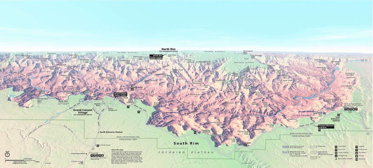 Grand Canyon Panorama Map