Sevilleta NWR--Unit A
Sevilleta NWR--Unit A
La Joya, New Mexico 87028
Sevilleta National Wildlife Refuge Official WebsiteSevilleta National Wildlife Refuge Trails webpage
Sevilleta National Wildlife Refuge Hunting webpage
Amigos de la Sevilleta webpage
Sevilleta National Wildlife Refuge map
Tips for Birding
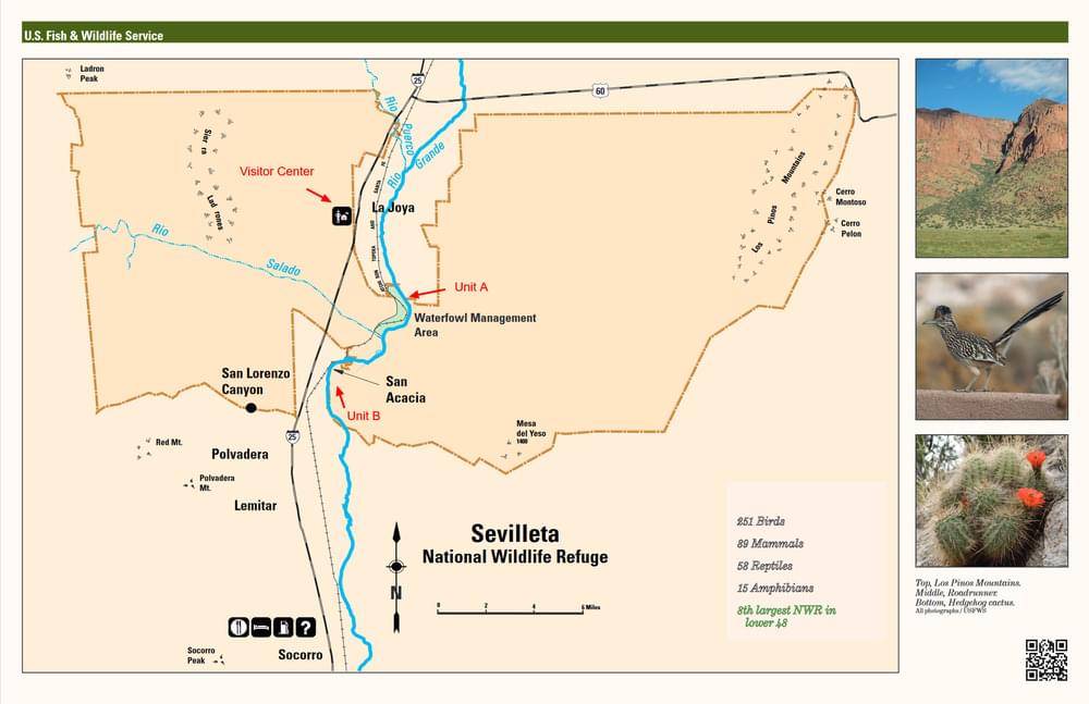
Sevilleta NWR–Unit A is an area-specific hotspot within Sevilleta National Wildlife Refuge. It is located south of the La Joya Wildlife Management Area (WMA) and north of Sevilleta Unit B, bounded on the east by the Rio Grande River and on the west by the BNSF railroad tracks. Observations in the WMA or at other locations around the Refuge should not be reported for Unit A.
Unit A can only be reached by driving through the state WMA; though you can drive the “washboard” through the WMA year-round (weather permitting), the WMA itself is closed to all recreational activities except hunting from September 1 to March 14.
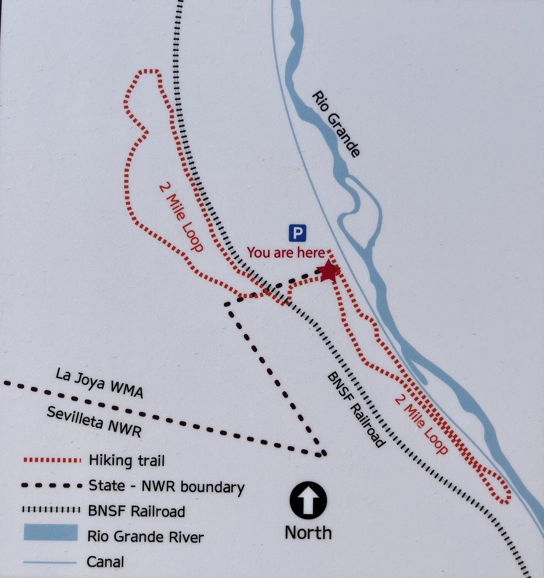
A popular way to bird Unit A is to go south on the road west of Drain Unit 7, cross east across the Drain at the parking area for Unit B, and return north on the road east of the Drain and west of the Rio Grande. To reach this counter-clockwise loop, directly after crossing the railroad tracks while still in the WMA, you would not continue east across the Drain, but turn south at the orange “Road Closed Ahead” sign; this sign pertains to the locked gate at the south end of Unit A (between Units A & B), though it is always prudent to check the Refuge website and/or phone regarding closures, particularly after wet weather.
Following this route, south of the dirt parking area near the gate between the WMA and Unit A is a map showing two birding trails. One two-mile birding loop trail is contained in Unit A, south of the north parking area; the other birding trail, of similar length, lies mostly in the southern portion of the WMA but begins in Unit A, running first west from the north parking area, then north into the WMA. (Observations along the WMA portion of this trail are more appropriately recorded for the La Joya South End hotspot.) Immediately before turning north and entering the WMA, this second trail passes by a pond (commonly known as the “Railroad Pond” because it is directly east of the railroad tracks) which often has water after the waterfowl hunting ponds have been drained. Particularly in spring, it is worth the short walk from the parking area, even if you are not birding the entire trail. Both trails are on the west side of Drain Unit 7, the main ditch running south through the Refuge west of the Rio Grande, and are west of the north-south road west of the Drain.
The Refuge website has excellent maps available on its trails page (a submenu selection under “Visit Us”). Clicking on the “View Trails” button takes you to a map of your selected trail with each trail section’s length given. Unit A and Unit B trails are very briefly described together under the heading “Wetland Units”, but first-time visitors should be aware that the statement there that the road surfaces are paved is not true. While not requiring a high-clearance vehicle, these dirt roads can become impassable after significant rain. Note that Drain Unit 7 is mislabelled on the website maps as “Socorro Main Canal”; the latter does not begin until below San Acacia Dam. Do not expect to be able to view the website while in Unit A, as cell phone connectivity is poor.
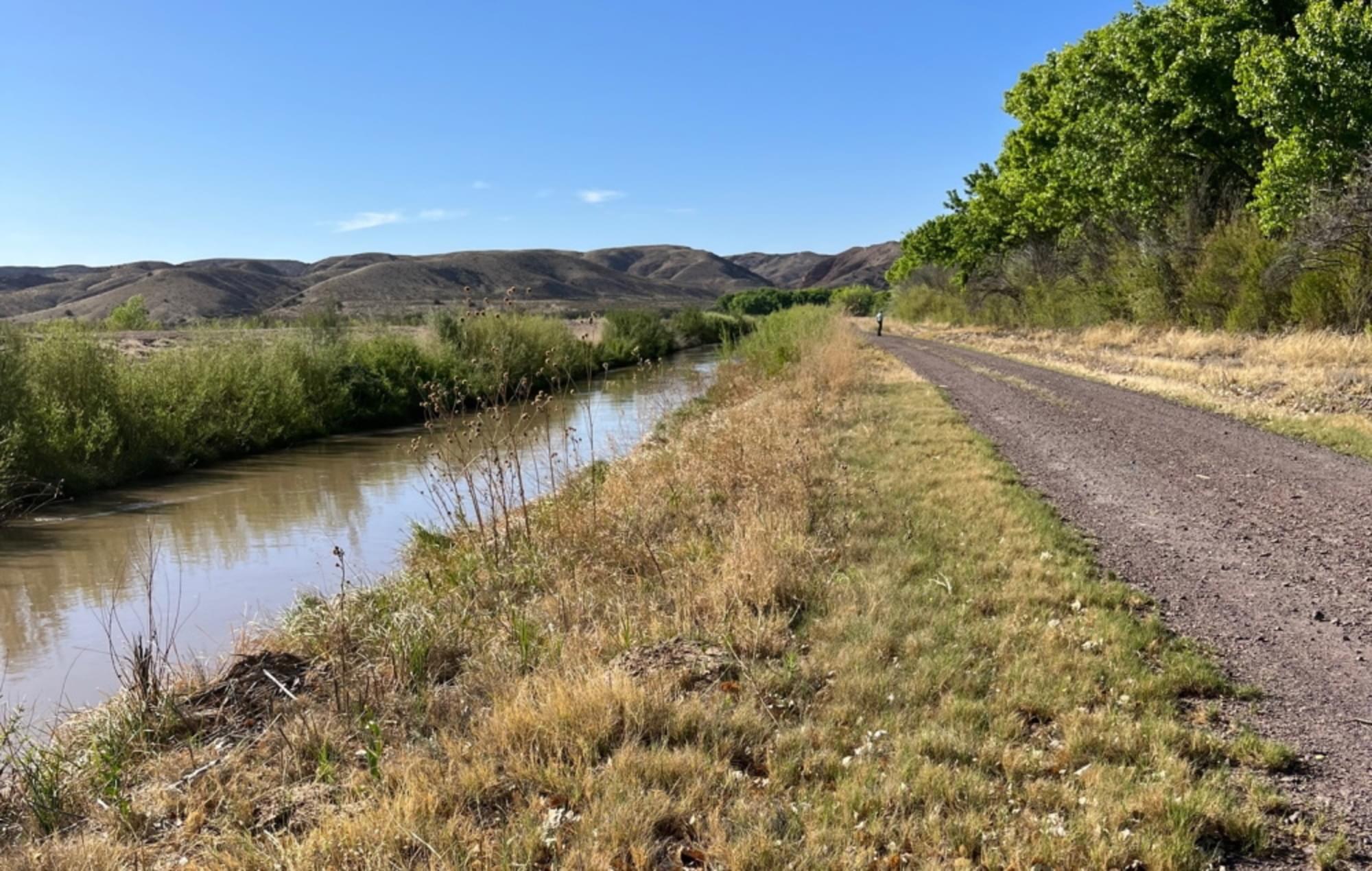
In the first mile south of the north parking area, between the road following the Drain westside road and the railroad tracks, are a few waterfowl hunting ponds, which May through August may appear to be meadows. These open areas are surrounded by cottonwood, Russian olive, and a few Gooding’s (Black) willow as an upper canopy, with coyote willow, New Mexico olive, and other shrubs for the understory. This is a good area to listen for Yellow-billed Cuckoo from June through August. From the north gate, the road continues south two miles to Unit B; just before the gate into that unit, you can cross the Drain and drive back through Unit A on the ditch’s east side.
A narrow strip of cottonwood and willow bosque lies between the Drain’s eastside road and the river back to a gate to the WMA. The Refuge website advises visitors to stay on the road, rather than hike into the bosque. This is not a big loss to birders; the strip of vegetation between the road/levee and the river is so narrow you will be able to detect most birds there from the road/levee, and visibility up or downstream would be extremely limited by the vegetation even if you could get to the river bank. Also, good birding can be had from the road and low levee at the parking area for Unit B, where the USFWS has done significant clearing of tamarisk, replacing the invasive exotic with native cottonwood and willow. From mid-May to at least mid-June, male Southwestern Willow Flycatchers can be heard calling from the wider swath of cottonwood and tamarisk across the river at that point.
There are at least 5 cautionary notes of importance.
1) Observe all signage. Exploration off-trail is generally prohibited, though most roads and levees, as well as trails in the wetland units, may be hiked.
2) If hiking in the summer, hydrate beforehand, carry adequate water, protect yourself from the sun, and be mindful of rattlesnakes.
3) In late spring or early fall, insect repellent will make your birding safer and more comfortable.
4) If it has been wet, call the Refuge to find out whether wetland unit roads are passable.
5) Know which areas are open to hunting and when. It is worth restating that the State WMA, which you must drive through to get to the Refuge wetland units, is closed to birding from September 1 to March 14. Refuge Units A and B are typically open for dove hunting beginning in September, and then for waterfowl in October, with some seasons lasting through January 1. The two units may be open on different days of the week, but there should be at least one day a week during hunt seasons when both units are free of legal hunters. If planning a trip during fall or early winter, examine the Refuge website’s hunting page; if phoning for clarification, do so well in advance as it could require your leaving a message and receiving a return call. USFWS personnel will have information about hunting on the Refuge, but should not be expected to have information about hunting at the state WMA.
Birds of Interest
Willow Flycatchers, an endangered species, have been observed here in June.
Yellow-billed Cuckoo, threatened throughout the western US, has been recorded June-August.
Bell’s Vireo, a threatened species in New Mexico, is observed May-July.
Other species: Rufous Hummingbird (Aug), Woodhouse's Scrub-Jay (Oct-Dec), and Phainopepla (May-Aug).
About Sevilleta National Wildlife Refuge
See all hotspots at Sevilleta National Wildlife Refuge
Sevilleta National Wildlife Refuge is one of the largest refuges in the National Wildlife Refuge System in the lower 48 states.
The 230,000-acre refuge includes four different biomes that intersect and support a wide array of biological diversity. The Rio Grande flows through the center of the refuge and is an important source of water that creates an oasis for wildlife in the arid landscape. Scientists from across the country and internationally come here to conduct research in these amazing ecosystems. The refuge is unique in that it was set aside “to preserve and enhance the integrity and the natural character of the ecosystems of the property by creating a wildlife refuge managed as nearly as possible in its natural state.” Thus the refuge is not managed for specific wildlife species but to allow natural processes such as flood and fire to prevail.
Sevilleta National Wildlife Refuge is unique because four different kinds of biomes intersect on the refuge, including the Colorado Plateau Shrub Steppe, Great Plains Short Grass Prairie, the Chihuahuan Desert, and the Pinyon-Juniper Woodland.
A biome is a regional ecosystem with distinct types of vegetation, animals, and microbes that have developed under specific soil and climatic conditions. The result: an area with a remarkable array of plant and animal life.
The Colorado Plateau is a large geological slice of western North America and reaches its southeastern limit on Sevilleta National Wildlife Refuge. The Colorado Plateau Shrub Steppe is one of the many biomes found within the Colorado Plateau and is a sparse, windswept environment; not quite desert, but definitely not the forest. The sagebrush, saltbush, and grasses of the shrub-steppe thrive in conditions where few plants can survive and support many different wildlife species.
The Great Plains Short Grass Prairie has wide open spaces, sunshine, and acres of nutritious grasses and flowering plants – exactly what animals of the grassland need. The Gunnison’s prairie dog is one of the main architects of the prairie. They create elaborate underground burrows with long tunnels for hiding, nesting, and escaping extreme heat or cold. Within the grassland, many ground-dwelling animals find shelter in the network of tunnels and burrows built by prairie dogs and also kangaroo rats.
The Chihuahuan Desert appears forbidding to humans, but this dramatic landscape is home to an amazing array of life. Creosote bushes interspersed with yuccas, grasses, and cactus give this desert its characteristic appearance.
The Pinyon-Juniper Woodland supports two main tree species: pinyon pine and one-seed juniper. Both tree species provide high-quality food for wildlife throughout the year in the form of juniper berries and pinyon seeds. This biome shelters and supports some of the area’s larger wildlife such as black bear and mountain lion.
In addition, the Rio Grande flows through the center of the refuge creating an oasis along the river that plays a vital role within these mixed ecosystems. Because the environments are so diverse, they attract and support a wide diversity of native species, including 251 species of birds, 80 species of mammals, 58 species of reptiles, 15 species of amphibians, and more than 1,200 species of plants.
The more commonly seen wildlife on the refuge includes mule deer, coyotes, pronghorns, snakes, lizards, and many different types of birds.
Notable Trails
The Refuge website has excellent maps available on its trails page (a submenu selection under “Visit Us”). Clicking on the “View Trails” button takes you to a map of your selected trail with each trail section’s length given. Unit A and Unit B trails are very briefly described together under the heading “Wetland Units”.
Features
Roadside viewing
Restrooms on site
Wheelchair accessible trail
Entrance fee
Content from Sevilleta National Wildlife Refuge Official Website and John Montgomery
Last updated January 18, 2024