Maidstone State Park / State Forest
Maidstone State Park / State Forest
Guildhall, Vermont 05905
Official WebsiteMaidstone State Forest webpage
Maidstone State Park map
Nulhegan Basin IBA (National Audubon) webpage
Nulhegan Basin IBA map
About this Location
Maidstone is the most remote of Vermont’s state parks and still retains much of the character associated with the Northeast Kingdom. Maidstone Lake was created when glacial ice carved out a deep basin in a preexisting valley. When the last glaciers melted 12,000 years ago, a deep, clear, and cold lake was formed.
The lake offers good lake trout and salmon fishing and has had some outstanding record catches. Maidstone Lake is a great location to view nesting loons. The loon loves the solitude of the northern lakes whose shores are rimmed with spruce-fir shade. Once common in Vermont, the loon has recently been removed from the endangered species list but remains a species of concern.
Maidstone was designated by the state of Vermont as a state park in 1938. The camp areas were wilderness, but the area around the lodge was a Civilian Conservation Corps camp. The CCC built many sites with fireplaces for camping, the lodge, and a picnic shelter, which are still in use today.
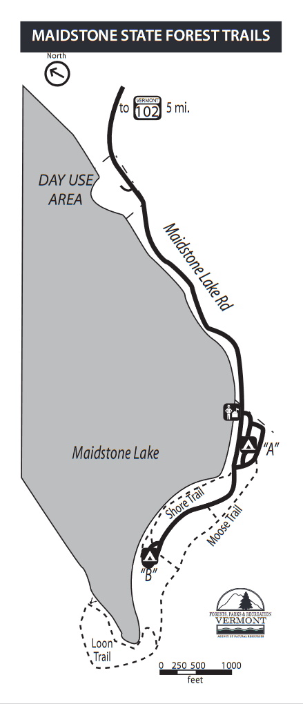
Maidstone State Park has three hiking trails to help you explore the boreal forest and lake. All are easy hiking and can be completed in less than an hour. All trails are marked with blue blazes.
About Nulhegan Basin Important Bird Area
See all hotspots at Nulhegan Basin Important Bird Area
This is a large area in the Vermont context; 25,700 acres (40 square miles). It is 21 miles north to south; and 10 miles west to east at the widest. It is the most boreal of Vermont’s landscapes, in large part due to its height above sea level. It has good examples of a variety of boreal ecosystems enhanced by significant topographical relief in spite of no major, tall mountains. The size and shape of the IBA reflect its history of ownership rather than ecological boundaries. Cherished in that part of the state are the expanses of unbroken wildlands notwithstanding the logging history.
The Nulhegan Basin IBA is Vermont’s largest IBA comprising a mosaic of forest and wetland habitat types. The predominance of boreal habitats is typical of forests found further to the north and as such supports a number of species rarely found in Vermont. The IBA is centered around the Nulhegan Basin and stretches from Lewis Pond in the north to the Granby Stream and its tributaries to the south. Included in this area are the Moose, Ferdinand, and the Yellow bogs. Vermont Natural community types include Lowland and Montane Spruce-Fir forests, Northern Hardwood Forest, Spruce-Fir-Tamarack and Black Spruce swamps, Dwarf Shrub, and Black Spruce Woodland bogs and Intermediate Fen.
This IBA includes the Conte National Wildlife Refuge and Wenlock and West Mountain Wildlife Management Areas as well as a number of other state-owned lands. Much of this land was acquired through one of the largest land deals in Vermont. Controversy has revolved around the management of the state lands and access to areas for timber harvesting. Surveys for Spruce Grouse are conducted every 2 years. Other issues include the accidental shooting of Spruce grouse by hunters and invasive species.
Notable Trails
Moose Trail (.75 mile)
This is the place to walk if you would like to search for wildlife signs such as moose and red squirrels. The trail leaves from the right side of the road near sites 22/23 in campground area A. You will walk through a spruce-fir forest, cross two streambeds and take a sharp left turn uphill. Next, you will pass an old logging area and wind uphill through thick woods to the top of the hill. Note the glacial erratics (large boulders left by glaciers) in the forest here. Follow the trail downhill until you come to a T intersection on an old logging road. The right fork leads to the main road. Turn left and pick up the trail again in a few yards on the right. Continue to follow the trail where it ends in campground area B in between lean-tos Juniper and Boxelder.
Loon Trail (.5 mile)
This trail travels along the rocky shoreline to the south end of the lake, and it is a perfect place to walk to look for loons. The trail leaves from campground area B in between sites 33 and 35. You will enter the woods and quickly turn left heading uphill. Soon you will turn to the right and level out for a little while, and then head steeply downhill towards the lakeshore. Follow the trail along the shore to the end of the lake, then walk around a short loop, and head back following the same path. You will end back at your starting point.
Shore Trail (.5 mile)
Follow this hike through cedar and hemlock woods along the lakeshore. The trail hugs the shoreline between the camper’s beach in campground area A and the bathhouse in campground area B.
Features
Restrooms on site
Entrance fee
Wheelchair accessible trail
Content from Official Website, Nulhegan Basin IBA (National Audubon) webpage, and Ian Worley
Last updated October 18, 2023