Headwaters Trail--Asbury Rd. Trailhead
Tips for Birding
This is the only hotspot that has been established for this trail. If you visit a different section of the trail, please suggest an additional hotspot.
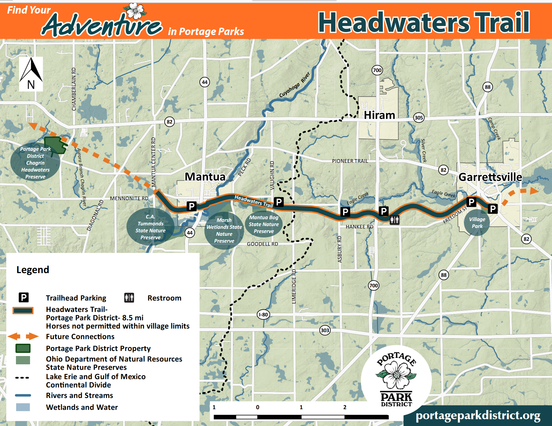
There is a small parking area at the Asbury Road trailhead. Deciduous forest habitat with some forest edges predominate around this trailhead. In close proximity to this trailhead, three small tributary streams flow north into Eagle Creek, crossing the Headwaters Trail. The two streams east of the trailhead move through deep, rocky ravines and have waterfalls.
Birds of Interest
Passerines, warblers, flycatchers, vireos, and thrushes common to eastern North American forests and forest edges during migration and breeding season.
Louisana Waterthrushes singing in mid-May near both waterfalls east of the trailhead.
In the Summer months: Hooded Warbler, Ovenbird, Blue-winged Warbler, American Redstart, Yellow-throated Vireo, Willow Flycatcher, Acadian Flycatcher, Veery, Wood Thrush, Scarlet Tanager, Indigo Bunting, Rose-breasted Grosbeak, and Yellow-Billed Cuckoo.
In migration: Swainson's Thrush, Tennessee Warbler, Magnolia Warbler, Bay-breasted Warbler, Blackburnian Warbler, Black-throated Warbler, and Chestnut-sided Warbler.
About this Location
The eight-and-a-half-mile limestone-paved Headwaters Trail, built on the former Cleveland-Mahoning Railroad line between Mantua and Garrettsville, provides a safe and scenic route for hikers, bikers, and horseback riders. It passes by beautiful farmland and forests, steep ravines, and wetlands, including State Nature Preserves, and the Upper Cuyahoga State Scenic River.
Named Headwaters Trail because of the area’s extensive wetlands, springs, and headwaters streams, the trail also crosses a continental watershed divide, between the Mahoning River Watershed that drains to the Ohio River then to the Mississippi River, and into the Gulf of Mexico, and the Cuyahoga River Watershed, draining to Lake Erie then out to the North Atlantic Ocean.
Portions of the Headwaters Trail have been designated as part of the Buckeye Trail system that circles the State of Ohio. Camp Asbury is also on the Buckeye Trail and adjacent to the Headwaters Trail. The railroad operated as a passenger and freight line from Youngstown to Cleveland until the mid-1970s. Much of the line is now out of service, and in private ownership. The State Route 700 trailhead is the site of the former Jeddoe Station. Historic stories of the railroad include a train robbery and great escape in Garrettsville, and a tragic boiler accident, these stories can be found on interpretive signs along the trail.
Notable Trails
Day hikes of varying lengths are possible from trailheads on the Headwaters Trail.
East of the trailhead, the Buckeye Trail intersects with the Headwaters Trail, providing hiking access to the north and south.
East of the trailhead, two small spur trails go south from the Headwaters Trail providing access to Almuth Falls and Ten Foot Falls.
Features
Wheelchair accessible trail
Restrooms on site
Entrance fee
Roadside viewing
Content from Official Website and Alex Colucci
Last updated January 31, 2024