Hocking Hills SP--Cedar Falls
Hocking Hills SP--Cedar Falls
Logan, Ohio 43138
Official WebsiteHocking Hills State Park Official Website
Hocking Hills State Park map
Hocking Hills trail maps
Athens Area Outdoor Recreation Guide Hocking Hills State Park
Also, see all the hotspots at:
Hocking Hills Important Bird Area
About this Location
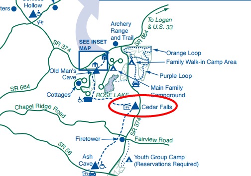
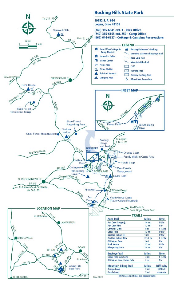
If one were to venture down the Lower Gorge of Old Man’s Cave, you would eventually enter the picturesque valley of Queer Creek. At the point where Old Man’s Creek merges with Queer Creek, the trail takes an abrupt turn east and enters this new valley. The trail leading to Cedar Falls passes through the most austere area in Hocking Hills. This remote, primitive chasm is laden with hemlock and bound by steep rock walls and their accompanying grottos and waterfalls. It is a wild and lonely but spectacularly beautiful place.
Cedar Falls itself is the greatest waterfall in terms of volume in the Hocking region. Queer Creek tumbles over the face of the Blackhand sandstone displaying the awesome force of water power.
In the mid-1800’s, a grist mill was built above the falls to utilize this water power for grinding grain.
Cedar Falls was misnamed by early white settlers who mistook the stately hemlocks for Cedars. A well-kept picnic area and restrooms are located in the parking area above the falls.
About Hocking Hills State Park
See all hotspots at Hocking Hills State Park
The natural history of this region is as fascinating as the caves are beautiful. Here, in these sandstones and shales, one can read Ohio’s history from the rocks. The scenic features of the six areas of the Hocking Hills State Park complex are carved in the Blackhand sandstone. This bedrock was deposited more than 350 million years ago as a delta in the warm shallow sea which covered Ohio at that time. Subsequent millions of years of uplift and stream erosion created the awesome beauty seen today.
The sandstone varies in composition and hardness from softer, loosely cemented middle zone to the harder top and bottom layers. The recess caves at Ash Cave, Old Mans Cave, and Cantwell Cliffs are all carved in the softer middle zone. Weathering and erosion widened cracks found in the middle layer of sandstone at the Rock House to create that unusual formation.
Other features of the rock include cross-bedding, honeycomb weathering, and slump blocks. The first is noticeable as diagonal lines in the rock intersecting horizontal ones. It is actually the cross-section of an ancient sandbar in the delta and was caused by changing ocean currents. Honeycomb weathering looks like the small holes in a beehive comb. They are formed by differential weathering which comes about when water, moving down through the permeable sandstone, washes out small pockets of loosely cemented sand grains. Finally, the huge slump blocks of rock littering the streams tumble from nearby cliffs when cracks widen to the extent that the block is no longer supported by the main cliff.
Although the glaciers never reached the park areas, their influence is still seen here in the form of the vegetation growing in the gorges. The glaciers changed the climate of all of Ohio into a moist, cool environment. Upon their retreat, this condition persisted only in a few places such as the deep gorges of Hocking County. Therefore, the towering eastern hemlocks, the Canada yew, and the yellow and black birch tell of a cool period 10,000 years ago.
Notable Trails
The AllTrails website has a description and map of a hike to Cedar Falls.
Features
Restrooms on site
Content from Official Website, Hocking Hills State Park Official Website, and Ohio Ornithological Society