Salt Fork SP

Salt Fork SP
14755 Cadiz Road Lore City, Ohio 43755
Salt Fork State Park Official WebsiteSalt Fork State Park map
Hiking Salt Fork State Park webpage
Salt Fork Wildlife Area map
Also, see all the hotspots at:
Guernsey County Birding Drive
Tips for Birding
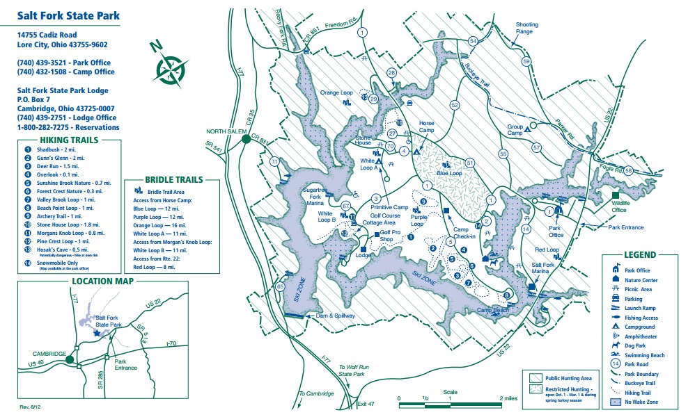
The area consists of forests, streams, valleys, meadows, and reservoirs. This is Ohio’s largest state park. There are 17,229 land acres and 2,952 water acres, 14 miles of hiking trails, and a small nature center. There is a bird list available, but, unfortunately, it is not of any great value. The main roads are paved, but a few of the small ones are gravel. Those are usually not accessible in the winter. Birding is usually good in the area behind the nature center, at the marinas, and on the beach road as well as along the various gravel roads. There is a lodge, which has 148 guest rooms and 37 two-bedroom cottages.
To reach the park from I-77, travel east on OH-22 to the main park entrance. A map is available at the nature center.
Open all year during daylight hours.
Camping in the park: 212 sites, all with electricity, 18 sites are wheelchair accessible. Group camp and horsemen’s camp are available. There is an 18-hole golf course. The rangers hold Summer Nature Programs. Swimming, fishing, boating, and hunting all take place in the park.
Birds of Interest
Winter
American Tree Sparrow, Dark-eyed Junco, White-crowned Sparrow, White-throated Sparrow, Winter Wren, Red-tailed Hawk.
Spring
Cliff Swallow, Osprey, Red-shouldered Hawk, Belted Kingfisher, Yellow-throated Warbler, Spotted Sandpiper, various ducks in migration.
Summer
Scarlet Tanager, Red-headed Woodpecker, Wild Turkey, Turkey Vulture, Black Vulture, Northern Mockingbird, Killdeer.
Fall
Blue Jay, Downy Woodpecker, Ring-billed Gull, Canada Goose, various ducks and grebes.
About Salt Fork State Park
See all hotspots at Salt Fork State Park
Before settlement, Ohio lay in the heart of a vast forest wilderness stretching from the Appalachian Mountains to the Great Plains. None of the world’s hardwood forests surpassed this one in the variety and size of trees. Ohio’s forest was a magnificent sight and an enormous challenge for settlers determined to clear and till the land. Towering oaks, hickories, beeches, maples, walnuts, ashes, and chestnuts, some over 150 feet tall, rose from the rich fertile soil below. By 1900, most of Ohio’s original forest was decimated. In its place stood wheat, corn, oats, hay, and thriving cities
Through conservation efforts over the past few decades, a magnificent regrowth has occurred. Today, nearly 30 percent of the state is once again supporting a thriving forest. This is most evident in the rugged, unglaciated hill region of southeastern Ohio including Salt Fork State Park. Salt Fork contains a blend of rich woodlands and rolling meadows. The park contains diverse populations of plant and animal life. White-tailed deer, wild turkey, ruffed grouse, red fox, gray squirrels, and barred owls are well established within Salt Fork. Songbirds such as the scarlet tanager, cardinal, goldfinch, Kentucky warbler, and others provide delight for birdwatchers.
Spectacular wildflowers such as wild geranium, large-flowered trillium, violets, asters, and goldenrod line the forest floor and meadows. In spring, the melody of wood frogs, chorus frogs, and spring peepers echo through the park.
Salt Fork is said to have derived its name from a salt well used by Native Americans which was located near the southeastern corner of the park. Salt Fork lies in the unglaciated portion of the state. Throughout the area, thick-bedded, erosion-resistant sandstone or conglomerate overlays more erosive siltstone, shale, coal, and limestone layers, resulting in shelter caves, such as Hosak’s Cave, along with small waterfalls in the secondary drainages. Other interesting geologic features around the park are massive blocks of sandstone that have become detached due to the differential weathering and toppled down the slope.
Notable Trails
Salt Fork State Park Trails
Stone House Trail
The Stone House Trail is a 1.7-mile loop hike on a nature trail. Park in the lot where Park Road 4 crosses the lake. Cross the road to find the trailhead. Hike along the lakeshore to Stone House. On the return take the loop south away from the lake into the woods. Use the Salt Fork SP–Stone House Nature Trail hotspot to submit checklists of birds seen on this hike.
The is a description and map of this hike and several other hikes in the state park on the AllTrails website
There are 14 named hiking trails in Salt Fork State Park. In addition to the Stone House Trail:
Forest Crest Nature Trail – 0.32 Miles – Wheelchair Accessible, Paved, Easy
Archery Trail – 0.29 Miles – Easy
Deer Run Trail – 1.5 Miles – Moderate
Valley Brook Loop Trail – 0.8 Miles – Moderate
Hosak’s Cave Trail – 0.1 Mile – Moderate
Sunshine Brook Nature Loop Trail – 0.53 Miles – Moderate
Morgans Knob Loop Trail – 0.84 Miles – Moderate
Morgans Knob Trail – 0.62 Miles – Moderate
Pine Crest Loop Trail – 1 Mile – Moderate
Beach Point Trail – 1 Mile – Moderate
Gunn’s Glen Trail – 2 Miles – Moderate
Shadebush Trail – 1.9 Miles – Moderate
Portion of the Buckeye Trail – 6.86 Miles
Features
Restrooms on site
Wheelchair accessible trail
Content from Salt Fork State Park Official Website and Ohio Ornithological Society