Coal Oil Point Reserve (if possible, use more specific hotspot)
Coal Oil Point Reserve (if possible, use more specific hotspot)
Goleta, California, United States
Coal Oil Point ReserveNorth Campus Open Space
Tips for Birding
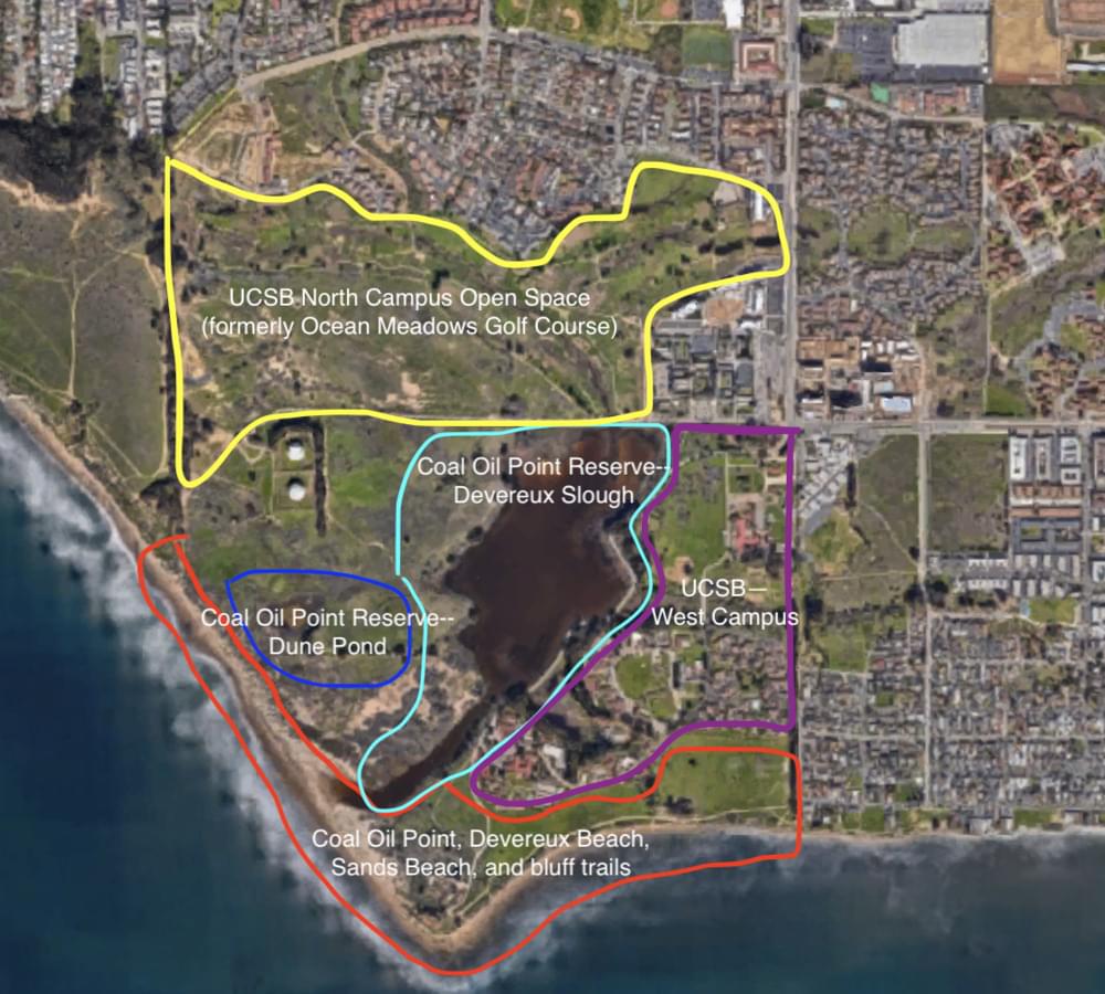
Several more specific hotspots exist for subsets of Coal Oil Point Reserve. Please consider using these:
Coal Oil Point Reserve -- Devereux Slough
Coal Oil Point, Devereux Beach, Sands Beach, and bluff trails
Coal Oil Point Reserve--Dune Pond
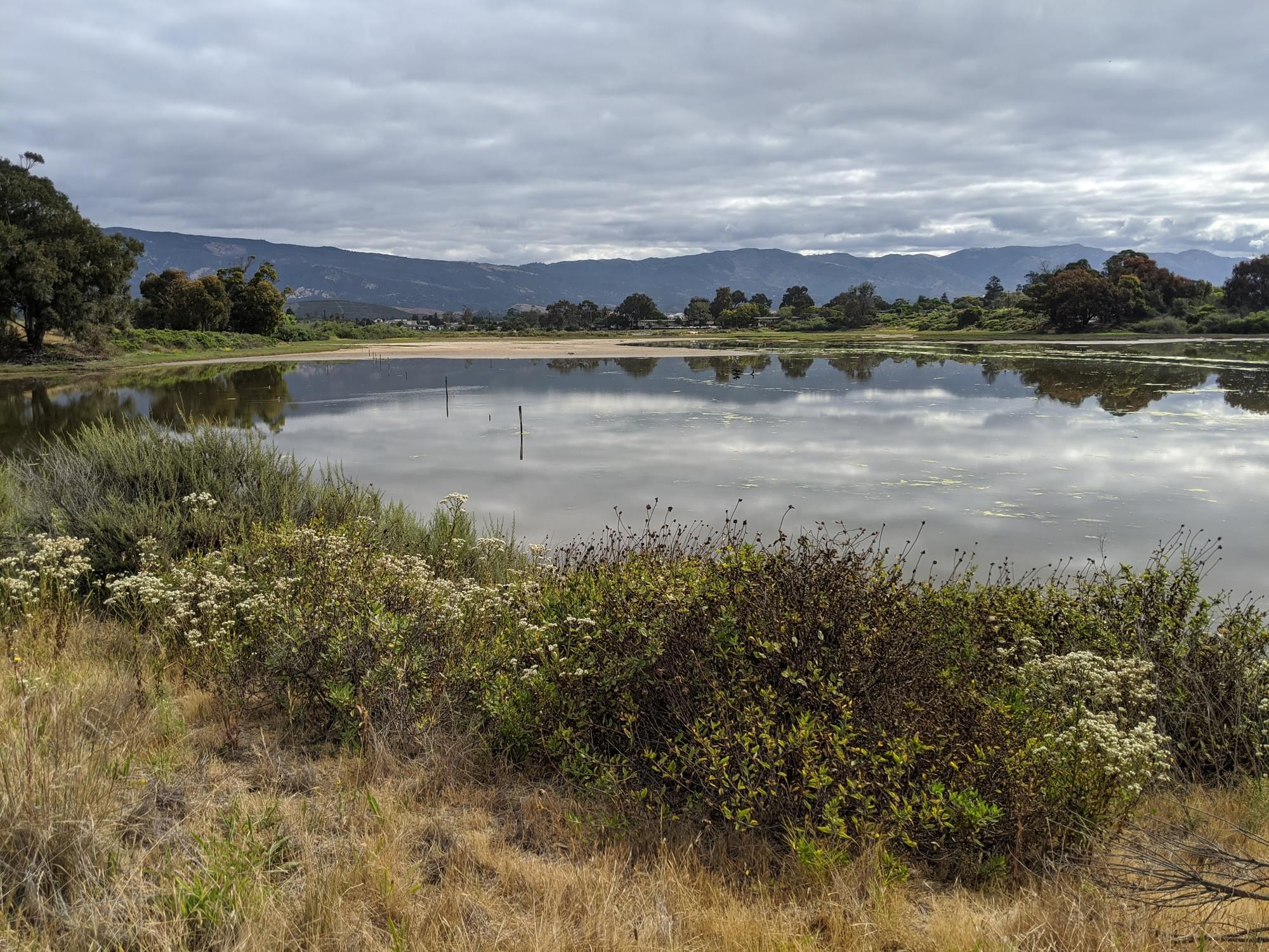
Effective birding strategies vary based on season and how much water is present. When large mudflats are exposed, scan them for shorebirds. When the Slough fills with water in winter it provides productive waterfowl habitat.
The shrublands along the Dune Pond trail can be good for sparrows and raptors during winter. In migration, check for passerines in the willow thickets and cottonwoods along the western slough boundary on COPR.
Birds of Interest
Shorebirds during spring and fall; waterfowl, sparrows, and raptors during winter.
Western Snowy Plovers nest on Sands Beach on the south end of this preseve. The Western Snowy Plover is listed as Threatened under the US Endangered Species Act. Intensive effort is undertaken by Coal Oil Point Reserve, the Santa Barbara Zoo, and Santa Barbara Audubon to protect this population of birds.
Belding's Savannah Sparrow (Passerculus sandwichensis beldingii), a subspecies of the Savannah Sparrow listed as endangered by CESA, has bred at this site and can often be heard in pickleweed patches in spring (note that other subspecies of Savannah Sparrows are common here in winter but very rare in summer).
About Devereux Slough Complex
See all hotspots at Devereux Slough Complex
Devereux Slough was once a larger and deeper estuarine wetland covering much of COPR and NCOS, with a permanent channel connected to Goleta Slough through what is now Isla Vista. It is fed by inputs from Devereux Creek (flowing through the Eucalyptus line in Ellwood Mesa), Phelps Creek (from the north, in the "North Parcel" restoration area), Whittier Channel (just west of the Whittier Parking Lot), and an eastern unnamed tributary.
In the 1861 water year, overgrazing combined with massive rainfall led to enormous sediment deposits in the Slough and turned it from a deep estuary into a salt marsh. During the 1960s, the northern portion of the Slough was artificially filled in to build Ocean Meadows Golf Coarse, which closed in 2013.
Now, the Slough alternates between tidal saltwater and pooling fresh or brackish water depending on the season. During most of the year, a sand berm where the Slough connects to Sands Beach prevents water from flowing into or out of the Slough. As the Slough fills with water during winter rains, it eventually breaks through the berm and empties into the ocean. For a period of several weeks it becomes tidal until the berm is reformed. From that point on, the Slough continues to fill until either it breaches again, or the rain stops for summer. During summer, the water in the Slough gradually evaporates, which causes the channel to become narrower and more saline. The process then repeats when winter rains return.
The southern portion of the Slough was named Coal Oil Point Reserve and incorporated into the University of California Natural Reserve System in 1970. Numerous University of California research projects have taken place at COPR over the last five decades. Active weeding programs use teams of volunteers and paid staff to maintain the natural grassland and scrub communities.
In 2017, UCSB's Cheadle Center for Biodiversity and Ecological Restoration purchased the former golf course to create a restoration site now known as North Campus Open Space. Restoration began in 2017 with substantial ground-moving efforts designed to produce salt marsh habitat that will be resilient to sea level change. The project is now nearing completion, and active restoration work on site will likely gradually slow over time.
Free parking is available for NCOS off of Whittier (34.4222, -119.8713). Parking is also available on COPR at (34.410822, -119.876781), but requires a UCSB parking permit or a day pass (paid at meters on site). Free street parking is available on Camino Majorca in western Isla Vista, which provides foot or bike access to COPR via the West Campus Bluffs Trails. A public portapotty is available by Coal Oil Point at (34.407781, -119.878912)
Notable Trails
A road runs along the eastern boundary of Devereux Slough and out to Coal Oil Point, providing views of the water or mudflats. Another trail runs through grassland and scrub habitat on the west portion of the boundary, out to the Dune Pond area, and eventually to Sands Beach. Beach use is restricted during the summer nesting period to wet sand along the wave line, to prevent disturbance to Western Snowy Plovers.
Features
Restrooms on site
Roadside viewing
Content from The Past, Present, and Future Hydrology of Devereux Slough, Coal Oil Point Reserve, North Campus Open Space, and Conor McMahon
 Devereux Slough Complex
Google Maps; Linus Blomqvist