Deer Creek Wildlife Area--East St. Wetland
Deer Creek Wildlife Area--East St. Wetland
Mount Sterling, Ohio 43143
Deer Creek Wildlife Area Official WebsiteDeer Creek Wildlife Area map
Deer Creek Lake webpage
Deer Creek State Park website
About this Location
The southern wetland tract is the newest, shallowest, grassiest, and most interesting area for birding. Shorebirds can be found here in the spring most of the time since there is usually some habitat for them. The surrounding grasslands host a wide variety of nesting species and migrants. Savannah Sparrows and Bobolinks can gather in large flocks here in the fall, and other migrant wetland species seen here recently include American Bittern, Black Tern, Common Moorhen, Sora, Nelson’s Sparrows, and Sedge and Marsh Wrens. Sandhill Cranes have occured here in their early spring migration. The grasslands also host a good variety of nesting sparrows including Savannah, Grasshopper, Henslow’s, Vesper, Field, and Song Sparrows. Dickcissels also occurred here in 2007 when I did my OBBAII work, but they haven’t nested here since. The grassland on the east side of the middle tract is similar and can be explored from the east ends of either of the two dikes. I found 3 pairs of nesting Blue Grosbeak in the drier open areas around these wetlands when doing my OBBAII work. Bell’s Vireos were also confirmed nesters in hedgerows. Two pairs were found in 2007 with one confirmed nesting. One singing male was again heard in 2008, 2009, and 2012. I didn’t find any Bell’s Vireos in 2010, 2011 and 2013, but the area is huge and there is a lot of suitable habitat available for them in the Deer Creek area. In 2014 two Bell’s Vireos again appeared in the same area and continued singing late into the nesting season, apparently successfully nesting. Two additional Bell’s Vireos were also found further north in the wildlife Area west of the reservoir in 2014.
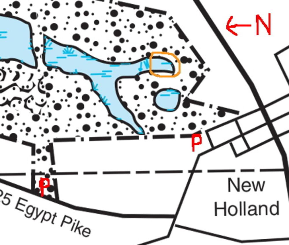
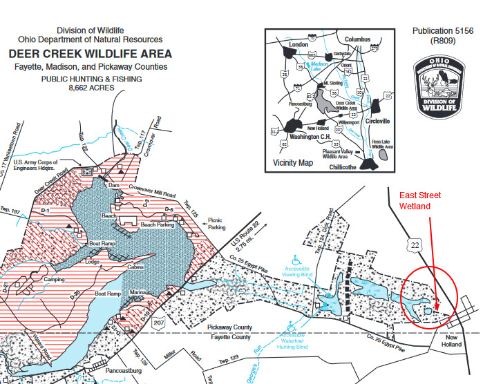
There is one more entrance to the southwestern corner of this tract in New Holland worth mentioning. It is not shown on the map either, but if you want to poke around this end of the grasslands it is worth the effort to find and since it can be the most interesting part of the wetlands for marsh and grassland birds seasonally, especially in late September and October. A gap in the fence surrounding the DCWA can be found on the corner of East St. and Water St. in New Holland (shown, but not named on the map). Google Maps shows Water Street named as “Walnut St.”. Other maps on the web such as Map Quest and Yahoo maps and, more importantly, the actual street sign call it Water Street. There isn’t a conspicuous parking area, so just park along the street or on the grass and enter the area where the fence ends just north of the corner. Walking eastward from this entrance a short way takes you to some shallow depressions filled with sedges that look like they were transported right out of North Dakota. LeConte’s and Nelson’s Sparrows and Sedge and Marsh Wrens are among the species recorded here in fall annually since 2011. Henslow’s Sparrows nest in the drier margins and have lingered into early winter. This area deserves further exploration and is easy to reach. Walking northward from this entrance will take you to the area described in the previous paragraph. The only word of warning for this area is that the pathways both eastward and northward from the entrance aren’t mowed and maintained consistently. In 2012 Marsh Wrens nested throughout the area and Sedge Wrens arrived from elsewhere for a second nesting later in the season, possibly as many as 25 pairs of them. Least Bitterns, Soras, and Virginia and King Rails are also on the list of probable nesters in this area in 2012. On the Deer Creek map a fork in the actual wet part is shown. Although it may be dried up by fall some years, it is always covered in cattails. The most productive way to bird this area is to walk along the edges of these forks. Since there has been some confusion amongst some birders as to where exactly I am talking about, see the map.
The red “P”‘s are the unmarked parking areas mentioned above. The best place in recent years for Nelson’s and LeConte’s Sparrows in October have been at the southern end of the southeastern of the two forks shown (the area circled in orange). To get there from the New Holland parking area walk eastward past the shown pond (which is usually dry in the fall) until you get to the cattails surrounding the fork. Not shown on the map just south of the SE fork is another pond filled with sedges and also surrounded by catttails that may contain some water. While the southeastern fork has been the best specific location to find these Ammodramus species in recent years, the whole area of the southern wetlands offers much similar suitable habitat and they could possibly turn up anywhere.
About Deer Creek Wildlife Area
See all hotspots at Deer Creek Wildlife Area
The 4,220-acre wildlife area is in central Ohio, four miles south of Mount Sterling on OH-207 and adjacent to the 1,277-acre Deer Creek Lake. It can be reached from the east and west by US-22 and OH-56, and from the north and south by US-62 and OH-3, OH-104, and OH-207.
The topography is flat to slightly rolling. The soils are mostly well drained and of medium to high productivity. Approximately 1,000 acres of row crops and small grains are under cultivation annually. Controlled burning and native warm season grass plantings have also been introduced as part of the wildlife management program.
About 25 percent of the wildlife area consists of second growth hardwoods and brush in advanced stages of succession. The timber stand is mainly on the east side of Deer Creek It includes oak, hickory, elm, black walnut, ash, maple, locust, sycamore, and cottonwood. Index of Ohio’s trees from the Division of Forestry. The uncropped remainder of the area is in permanent meadow, reverting fields, wildlife food plots, and prairie grasses.
Deer Creek Lake construction began in 1965 by the U.S. Army Corps of Engineers for flood control and was completed in 1968. Of the 7,575 acres, 6,875 are leased to the Ohio Department of Natural Resources for fish, wildlife, and general recreation purposes. Deer Creek State Park lies to the south and east of the lake and provides camping, picnicking, and boat launching facilities for the hunter and angler. Public hunting is permitted on some of the undeveloped 3,165 acres controlled by the Division of Parks and Recreation, and on all property controlled by the Division of Wildlife.
Wildlife management plans provide for the maintenance and protection of existing woodlands, establishment of field sizes and crop rotations beneficial to wildlife, improvement of open fields for wildlife nesting, and the establishment of annual food patches for general wildlife use. Permanent wildlife cover has been provided through the planting of native prairie grasses such as switchgrass, big blue stem, and Indiangrass.
Restrooms at Deer Creek State Park.
There is a handicapped accessible bird viewing blind at the Dick Road Wetland.
Content from Deer Creek Wildlife Area Official Website, Robert Royse’s Bird Photography Pages, and Ohio Ornithological Society