La Joya WMA--South End Walking Trail
La Joya WMA--South End Walking Trail
La Joya, New Mexico 87028
La Joya Wildlife Management Area information and mapTips for Birding
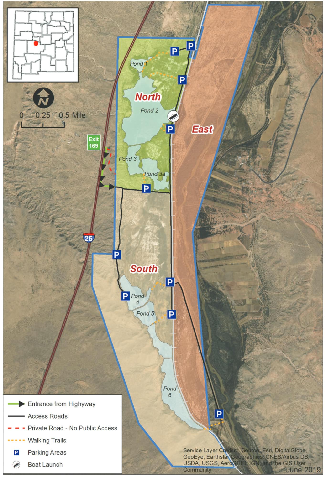
La Joya Wildlife Management Area (WMA), maintained by the State for dove and waterfowl hunters, comprises 3 hunt units. South End Walking Trail eBird species frequency bar charts likely include birds observed throughout the South Unit (south of the main east-west road and west of the railroad tracks), as the South End Walking Trail is the only hotspot in that hunt unit. It is helpful to researchers and other birders if you describe your birding route within the checklist “Comments”, and of course, WMA birds observed outside the South Unit should be recorded for the more general La Joya WMA hotspot. Note that the WMA is closed to all recreational activities except hunting from September 1 to March 14.
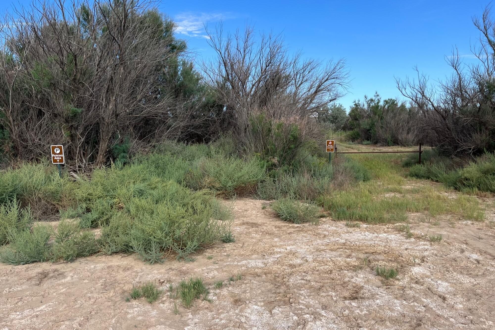
To access the hotspot trail, you can park just west of where the main north-south road west of the railroad tracks turns east to cross the tracks. The parking area and trail itself may be overgrown, with signage hidden by vegetation. The trail itself runs only about a quarter mile west to a two-track maintenance road atop a low levee between WMA Ponds 4 and 5, which are flooded during waterfowl hunting season (when no birding is allowed) and are meadows during summer. The eBird map pin for the hotspot is on this two-track, about halfway between where the two-track intersects the trail and where the two-track dead ends at a public dirt road (called by some the old San Geronimo road) to the southwest. Mornings have better lighting than afternoons for birding this trail.
It is possible to reach the South End Walking Trail from the west. At the hunt and WMA signage along the main east-west road less than half a mile from where you turned east to enter the WMA, turn south onto the San Geronimo dirt road (driveable in dry weather by a passenger car) through the Chihuahuan desert vegetation approximately a mile and a half to the second parking area, then walk about a half mile northeast along the levee. The way to the west end of the trail is not obvious, although this might be your preferred route for afternoon birding.
WMA South Unit Ponds 5 and 6 can be further explored by continuing south on either the road to the east trailhead of the South End Walking Trail (the road parallel to and immediately west of the railroad tracks) or on the old San Geronimo road. Both roads are closed to vehicles shortly beyond their second parking areas. Depending on the water level in the ponds, you can walk from the last parking area on the road directly west of the railroad tracks to the San Geronimo road, though again it’s not so obvious a path to do in the reverse. The two roads join one another at an east-west ditch forming the boundary between the WMA and Sevilleta National Wildlife Refuge’s wetland Unit A. Though the hike is on fairly flat ground, an entire loop from the second parking area just west of the railroad tracks down to the southern tip of Pond 6 and back is over 6 miles. A shorter loop may be made by cutting across a maintenance road through the south end of Pond 5. The advantage of hiking such a loop is that you get both the wetland birds of the pond areas (which retain water longer into the spring than the North Unit ponds) and the desert birds west of the San Geronimo road.
Conveniently, a two-and-a-quarter-mile walking loop around Pond 6 can easily be accessed from the northernmost parking area of Sevilleta NWR wetland Unit A. Walk a quarter mile west from that parking area down a maintenance road on the south side of an east-west ditch, cross the railroad tracks, and you will find a gate between the Refuge and WMA. Walk around the gate and begin your birding; observations from the parking area to the gate should be listed for Unit A, not for the WMA. The Refuge website has an excellent map of both the La Joya and Sevilleta portions of the trail shown as Section 001 of the Unit A Birding Trail on its Trails page; scroll down and click on the relevant View Trail button.
Be aware that cellular coverage is weak in most of the South Unit; you may not be able to submit a mobile eBird list until you exit the Unit. For the same reason, you may want to capture a photo of the area map on your phone before you enter the WMA.
There are at minimum 3 other cautionary notes of importance.
- When hiking in the spring, insect repellent will make your birding safer and more comfortable.
- If hiking in the summer, hydrate beforehand, carry adequate water, protect yourself from the sun, and be mindful of rattlesnakes.
- It is worth restating that the WMA is closed to birding from September 1 to March 14.
About La Joya Wildlife Management Area
See all hotspots at La Joya Wildlife Management Area
La Joya Wildlife Area, 3,405 acres, is located about 20 miles north of Socorro. La Joya Wildlife Area was purchased in various parcels through 1940 to provide habitat for waterfowl, sandhill cranes, shorebirds, and songbirds. The La Joya Wildlife Area contains ponds, canals, drains, and crop fields along and adjacent to the Rio Grande.
Wildlife watchers may see various waterfowl, songbirds, and quail. Good binoculars are important. The best time to view wildlife is at dawn or dusk. Access is allowed from March 15 to August 31.
La Joya is closed to wildlife viewing, photographing, hiking, bicycling, and horseback riding from September 1 to March 14.
Features
Restrooms on site
Wheelchair accessible trail
Roadside viewing
Content from La Joya Wildlife Management Area information and map and John Montgomery
Last updated March 22, 2024