Miller SP--Raymond Trail to Pack Monadnock, Peterborough
Miller SP--Raymond Trail to Pack Monadnock, Peterborough
Peterborough, New Hampshire 03458
Official WebsiteMiller State Park Official Website
Miller State Park map
About this Location
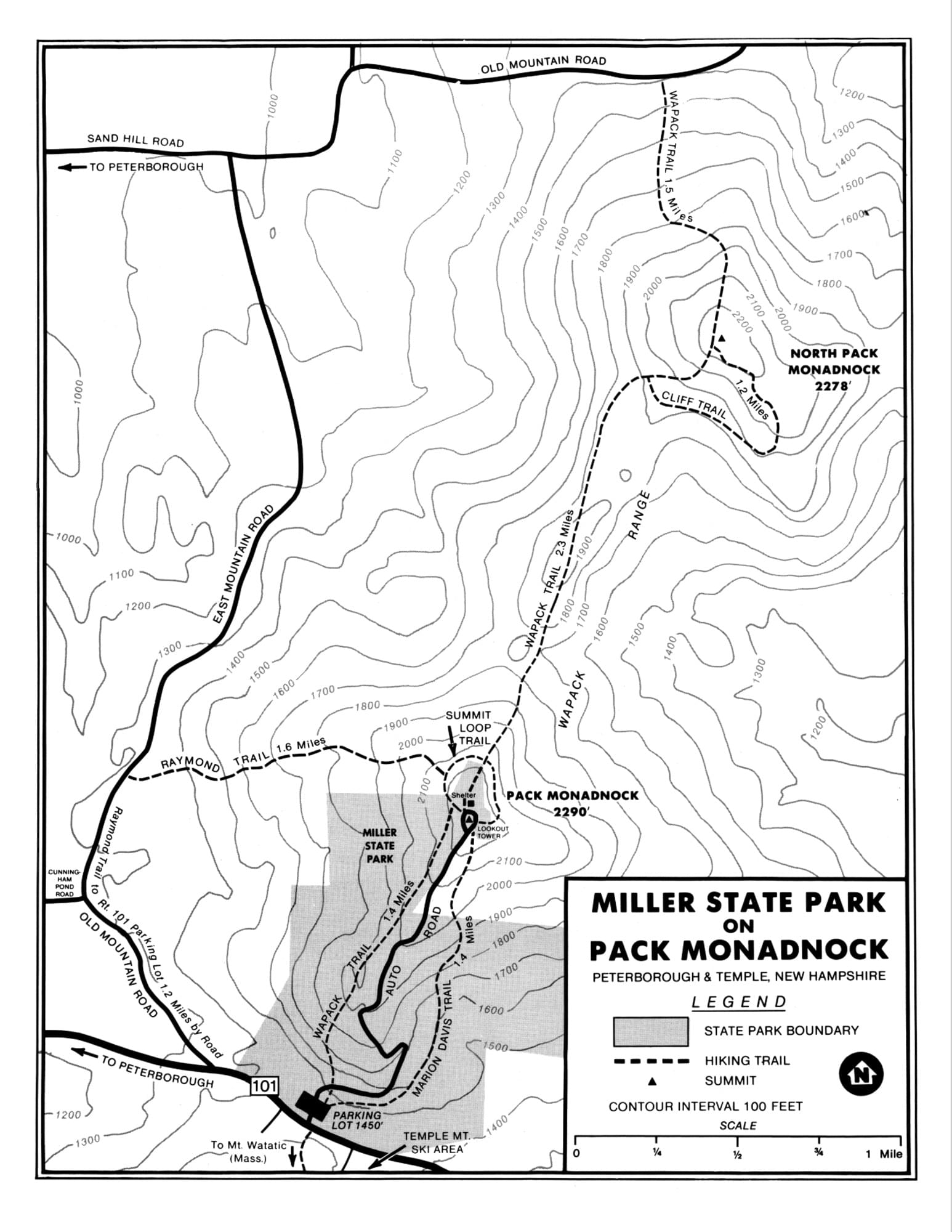
The Raymond Trail is a moderate to rugged 1.6-mile climb up the west side of Pack Monadnock. Near the summit, the trail joins the 21-mile ridgeline Wapack Trail.
There is limited parking at the trailhead on East Mountain Road, 0.9 miles north of NH-101. A larger parking area for the Cranberry Meadow Pond Trail is a short distance farther along, and that trail connects to the Raymond Trail by a short link.
The trail was designed by Friends of the Wapack and cut with assistance from Boy Scout Troop 808 on land given to the town by Joanne Bird Kane.
About Miller State Park
See all hotspots at Miller State Park
Located on the 2,290-foot summit and flank of Pack Monadnock in Peterborough, Miller is the oldest state park in New Hampshire. A winding 1.3-mile paved road leading to the scenic summit is open for visitors to drive in summer and on spring and fall weekends. Picnicking and hiking are popular activities at the scenic mountain park. Three main hiking trails ascend Pack Monadnock to the summit. The best known is the Wapack Trail, which is a 21-mile footpath that extends from Mt. Watatic in Ashburnham, Massachusetts to North Pack Monadnock in Greenfield.
A fire tower, no longer used for detecting fires, affords a panoramic view of the surrounding countryside. Mount Monadnock, 3,165 feet high, can be seen standing alone twelve miles to the west. It is believed Native Americans named the area’s mountains, and that “pack” means little. Other peaks and hills of southern New Hampshire and adjacent Massachusetts can also be seen. On clear days views reach Mount Washington, the skyscrapers of Boston, and the Vermont hills. Miller is a carry-in-carry-out park. Please carry your trash home with you and dispose of it properly.
New Hampshire’s first state park was created in 1891 when Charles F. Melendy and Austin A. Spofford deeded a three-acre tract of land on the summit of South Pack Monadnock to the state. The following year the park was dedicated in memory of General James Miller, a hero of the Battle of Lundy’s Lane in the War of 1812.
In the early years, all-day Sunday picnics at the summit were a popular pastime. Families would arrive by horse and wagon, with lunches packed in wooden cheese boxes, gallon jugs, and milk cans. In winter people enjoyed sledding, skiing, and snowshoeing on the mountain. Until 1901 cattle were driven by foot from Massachusetts farms to the park for summer grazing on what was then open pasture extending nearly to the summit.
A hotel called the Pioneer House was built in 1892 on a ridge on the southwest side of the mountain. Unprofitable for its first proprietor, George F. Barker, the business was sold three years after opening. The hotel burned to the ground in 1896, and a new, smaller structure was erected in its place. The new building was anchored to the rocks by iron rods and chains. It was used as a hunting lodge until it was abandoned and fell into disrepair. The building was destroyed by fire in 1924, but the foundation remains visible today.
In 1939 a twenty-seven-foot steel tower, topped with a wooden lookout cabin was erected to be used as a forest fire watch tower. The cabin no longer exists, but visitors can still climb the tower to enjoy the views.
Hikers are welcome on the trails of Miller State Park year-round. Three trails provide hikers access from the base to the summit.
The Wapack Trail (yellow blazes), a 21-mile footpath that extends from Mt. Watatic in Ashburnham, Massachusetts to North Pack Monadnock in Greenfield, New Hampshire, traverses the summit of Pack Monadnock. From the NH-101 parking area at the base of the auto road to the summit via the Wapack Trail is 1.4 miles. North of Pack Monadnock the Wapack Trail continues 3.8 miles through the Wapack National Wildlife Refuge, over North Pack Monadnock to Old Mountain Road.
The Raymond Trail (white blazes) begins on the west side of the mountain on East Mountain Road. The 1.6-mile trail was constructed cooperatively by Peterborough Boy Scout Troop 808 and the Peterborough Conservation Commission. It reaches the summit at the picnic area just north of the parking area.
The Marion Davis Trail (blue blazes) begins at the NH-101 parking area at the base of the auto road. It climbs 1.4 miles to the summit.
Notable Trails
The AllTrails website has a description and map of a hike on the Raymond Trail.
Features
Entrance fee
Restrooms on site
Wheelchair accessible trail
Content from Miller State Park Official Website and Raymond Trail website
Last updated October 21, 2023