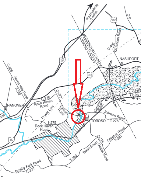
Dillon Wildlife Area--Toboso Rd. Wetlands
Dillon Wildlife Area--Toboso Rd. Wetlands
Toboso Road Southeast Newark, OH 43055
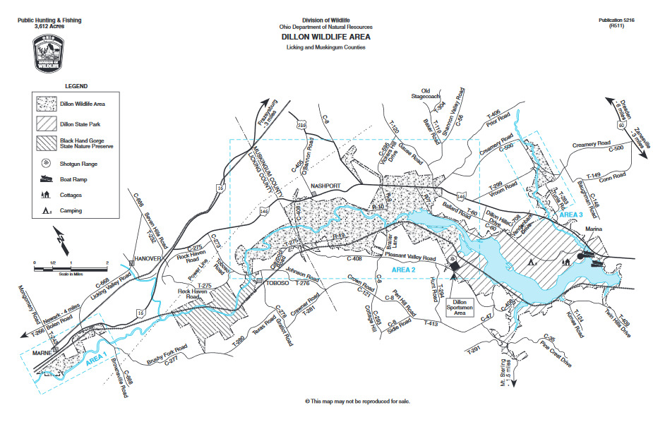
Dillon Wildlife Area Official WebsiteDillon Wildlife Area map
About this Location
The wetlands can be seen by hiking the Canal Lock Trail from its parking lot on the north side of Toboso Road west of where it crosses the Licking River. The gravel trail heads north and after a half-mile walk that parallels the Licking River, the wetlands can be seen to the north as the trail curves east.
About Dillon Wildlife Area
See all hotspots at Dillon Wildlife Area
The center of Dillon Wildlife Area lies 10 miles northwest of Zanesville and 15 miles east of Newark along OH-146. The area lies along the Licking River and the upper portion of Dillon Reservoir. Dillon is a flood control reservoir and most of the land base is characterized by broad, terraced floodplains, which are frequently flooded during the late winter and spring. Included also are adjacent rolling hills that border the Licking River valley.
Over half of the area is woodland with bottomland hardwoods (species including the sycamore, willow, and cottonwood) comprising 65% of the woodland acres. Small acreages of mast-producing oaks and hickories occur on the slopes and ridges of the surrounding uplands. Index of Ohio’s trees from the Division of Forestry.
Openland occupies about one-third of the area with 90% of the open land acreage under cultivation including corn, small grains, and meadows. The remainder lies in well-dispersed fallow fields of grasses and forbs and associated brushy field borders. Brushland covers less than 10% of the area.
Dillon Reservoir was constructed by the U.S. Army Corp of Engineers primarily for flood control. The project was authorized for construction by the Flood Control Act of 1938. After years of the relocation of railroads, roads, utilities, cemeteries, and small towns and delay resulting from World War II and the Korean Conflict, the dam was completed in September 1961.
Dillon Reservoir is a unit of the comprehensive program for flood control in the Ohio River Basin. It supplements the existing reservoir system in the Muskingum River drainage in controlling Muskingum and Ohio River floods. Flow regulation at the dam brings about vast fluctuations in water surface area. During the summer, when the flood threat is low, the water level is maintained at the 737-foot contour line, producing 1,560 surface acres of water. During the winter and spring flood season, the water level is dropped three feet to the 734-foot contour line, leaving 1,325 acres of water. Seasonal flooding frequently covers extensive acreage upstream from the reservoir.
Under a license from the federal government, the Ohio Department of Natural Resources, Division of Wildlife and Division of Parks and Recreation manage 8,200 acres of Dillon Reservoir area for wildlife and general recreational purposes. Wildlife management work on the 3,612-acre wildlife area has included protection and improvement of existing woodlands, selective maintenance of shrubby coverts, maintenance of permanent grasslands, maintenance of open land by cropland management, and improvement of the seasonal marshland.
Hunting and fishing are the major recreational uses, along with nature study, hiking, boating, and bird watching.
Restrooms at Dillon State Park.
Features
Restrooms on site
Content from Dillon Wildlife Area Official Website and Margaret Bowman