Deer Creek State Park
Deer Creek State Park
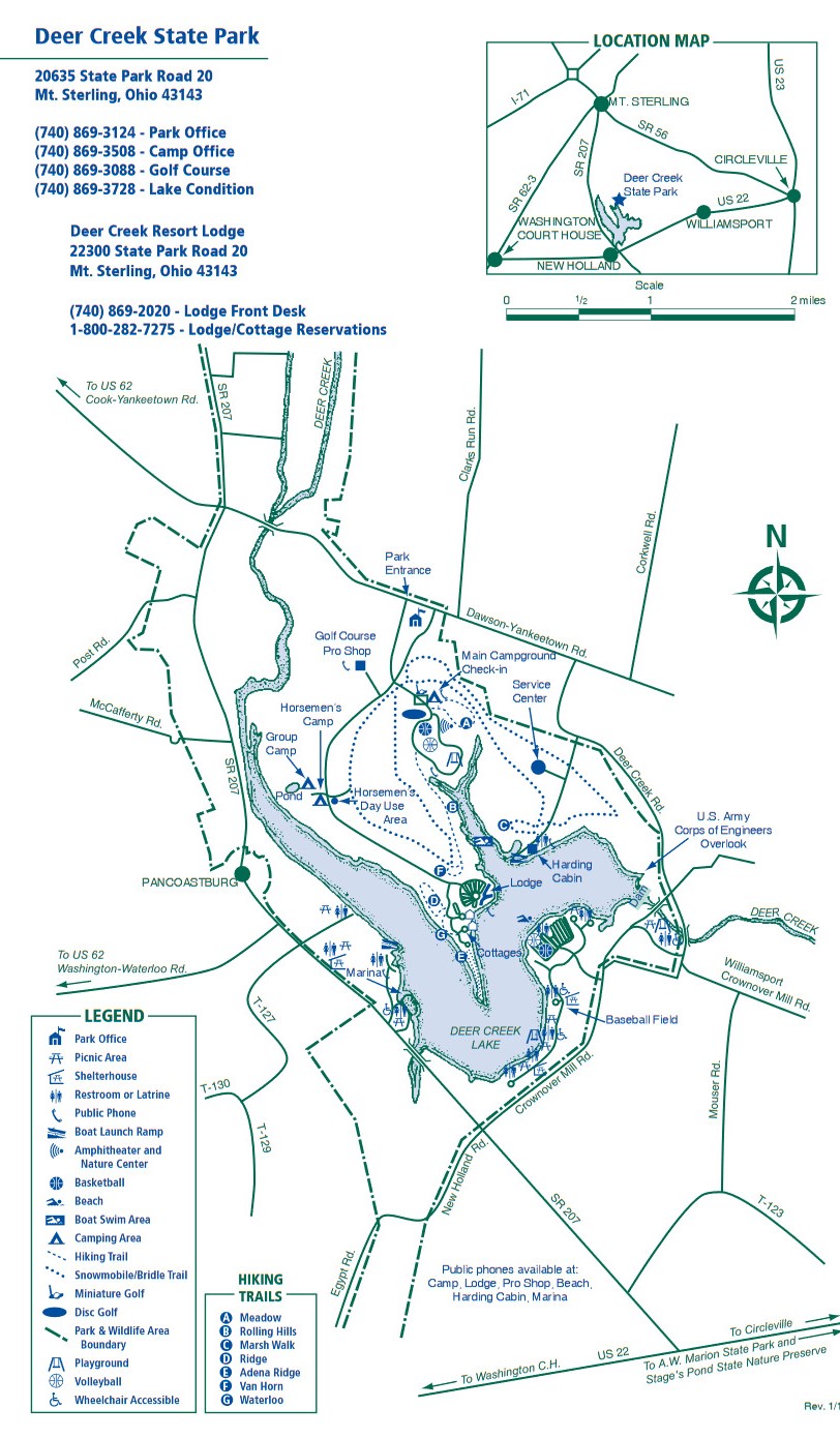
20635 State Park Road 20 Mount Sterling, Ohio 43143
Official WebsiteDeer Creek State Park map
Tips for Birding
The Deer Creek Reservoir and surrounding State Wildlife Area and State Park offer an interesting variety of habitats to explore any time of the year. When the reservoir is drawn down in October (exact dates vary from year to year) is when the area gets the most attention from birders during the fall migration. Because the water levels vary, there can be a rapid turnover in the species present. Fields and woodlands surround the reservoir.
In the southern part of the wildlife area, a wetlands complex on Dick Road offers additional interest. The Deer Creek area is the largest expanse of public land between what was once the Madison Plains and the Pickaway Plains, which is now mostly used for agriculture. These areas were of significance historically, and the Deer Creek area deserves closer scrutiny throughout the year, especially in early spring.
Because of the unusual shape of the reservoir and the varying heights of the water level, the whereabouts of the largest concentration of birds can be unpredictable. Driving along D-58 gives a good view of the upper reaches of the reservoir and is best when the water level is beginning to drop in October. Other vantage points definitely worth checking on the west side, especially later in the fall season, are the end of D-12 (“Miller Park”), and the general Marina area. On the south side of the reservoir, the beach offers a good view, and some of the parking areas along D-5 offer an excellent vantage point to scope out the SW portion of the reservoir. Above the dam wall offers another good vantage point for the SE part of the reservoir. Below the dam wall is a small park where it can be worthwhile to look for birds of riparian woodlands.
North of the reservoir, D-51 and D-52 offer good access into the fields that harbor Dickcissels and Grasshopper Sparrows in the summer, and large numbers of migrant sparrows in the fall. The wooded areas in the state park lands on the east side of the reservoir are most productive for migrant warblers during migration periods. The wetlands south of the reservoir can be explored by parking in any of the several designated locations along Egypt Pike and Dick Roads.
From the North (Columbus) take I-71 south to the Mount Sterling exit (OH-56) and head to Mount Sterling. From Mount Sterling follow the signs to OH-207 and take that south to the western side of the area. From the east (Circleville) take US-22 west to OH-207 or Crownover Road and head north to the area. Washington Court House is less than 10 miles to the southwest.
All areas of interest to birders are open during daylight hours.
Parking areas are numerous in both the state wildlife area and state park. Consult map. The large parking area at the beach is usually gated off beginning in November. Park staff currently has no objections to birders parking on the side of the road near the gate during late fall and winter.
Birds of Interest
Winter
If open water remains, many of the birds noted in the fall can continue into winter. American Tree Sparrows are abundant in the fields and Northern Shrike can occur. Black Vultures can sometimes be seen flying overhead. The wooded peripheries harbor the characteristic Ohio woodland species.
Spring
The upper reaches of the reservoir near Pancoastburg showcase one of the most easily observed Osprey nests in Ohio. The Deer Creek area is currently seldom birded in the spring, but the list of possibilities is long.
Summer
Characteristic nesting birds of Ohio are found in appropriate habitats. Dickcissels can be numerous in the fields during years when they’re present in Ohio.
Fall
Migrant waterfowl, loons, grebes, and gulls may be present in the thousands or relatively scarce, but something interesting always seems to be present. Some of the highlights seen in the reservoir in the fall of 2006 included Laughing Gull, Ross’s Goose, Long-tailed Duck, American White Pelican, and Red-necked Grebe.
In November 1995, a large concentration of 450 Sandhill Cranes used the northern part of the reservoir near Pancoastburg. While this number hasn’t been repeated, Deer Creek remains one of the most reliable places in Ohio to find Sandhill Cranes in the fall, with birds returning to roost in the evenings in small groups. The reservoir is drawn down in October after the main passage of shorebirds through the state, but the later migrating species, especially Killdeer and Dunlin, can occur in sometimes very large numbers. Other shorebirds noted (most annually) include Pectoral, Least, Western, and Baird’s Sandpipers, Greater and Lesser Yellowlegs, Long-billed Dowitchers, and Wilson’s Snipe.
American Pipits can be numerous on the mudflats in the fall, and Snow Bunting has been recorded. In September 2005 the Dick Road wetlands were kept at a low water level and a pair of American Avocets used the area for nearly a month. In 2006 a Northern Shrike was a fixture near the State Park beach. The wooded areas around the reservoir offer refuge to the full range of migrant passerines such as warblers, vireos, tanagers, and grosbeaks during September and early October. The fields in the wildlife area north of the reservoir can harbor some of the largest numbers of sparrows in the state during migration in October and November. Sunflower fields can congregate other passerines, mainly American Goldfinches, in gigantic flocks. Raptors are conspicuous in the fields of the wildlife area, mostly Northern Harriers and Red-tailed Hawks, but in 2006 Rough-legged Hawk and Golden Eagle were also recorded.
About this Location
Deer Creek State Park lies on the eastern edge of the great till plains of Ohio. These plains receive their name from the glacial debris, or till, which is a mixture of sand, silt, and gravel that was deposited by the glaciers. As glaciers advanced across the northern two-thirds of Ohio, most hills and valleys were covered and filled in by the till leaving this part of Ohio relatively flat.
Today, these rich plains in the park’s region support corn, soybeans, and wheat. The first settlers to the area did not find these open fields. Except for a few small prairie openings, the region was covered by dense woodlands. Regrowth of the original woodlands can be found scattered along the ridge tops and creek bottoms of the park.
Wildflowers abound in the fields and woodlands of the till plains. In spring, common flowers are Dutchman’s breeches, rue anemone, trillium, spring beauty, and bloodroot. The summer months produce thimbleweed, wild lettuce, jewelweed, and daisy fleabane. In autumn, the most abundant flowers are aster, goldenrod, and chicory, whose roots were used by settlers to make a coffee-like beverage.
The best-known animals of the Deer Creek area include amphibians such as the chorus frog, spring peeper, and American toad. Reptiles include box and painted turtles, black rat snakes, and eastern garter snakes. Numerous mammals inhabit the park. Most of them are small and include the red fox, raccoon, opossum, woodchuck, skunk, rabbit, deer mouse, and white-tailed deer. Deer Creek is known for its population of ring-necked pheasant. Other birds of the area include eastern meadowlark, song sparrow, cowbird, eastern bluebird, barn swallow, and woodcock.
Notable Trails
Deer Creek State Park Trails
Nine hiking-only trails are found at the park:
Adena Ridge Trail
This new .75-mile loop trail borders the lake shoreline the entire route. It boasts some excellent views of both the lake and beach area. It is a mostly wooded, partially uphill and downhill slope. It starts to the right of Cabin 25 and is marked with yellow blazes.
Hawkview Meadow Trail
A 1-mile loop trail that runs through an old oak wood lot before opening into a gentle rolling meadow. The trail is bordered by Clarks Run Creek and is mostly wooded, with some hills. It starts approximately 50 yards past the camp office and is marked with yellow blazes.
Lakeview Trail
This is a .5-mile easy hike.
Marsh Walk Trail
This is a 1-mile loop trail that traverses the shoreline and winds through hilly woodlands, including both a pin oak and oak woodlot. It starts at the east boat ramp parking lot. It is marked with yellow blazes.
Ridge Trail
This 1.5-mile trail runs through mostly wooded terrain with some shoreline hills. A nature observation blind allows the hiker to observe an area where wildlife may be enjoying corn or a salt block. It starts in the lodge parking lot near the baseball field and is marked with yellow blazes.
Rolling Hills Trail
This is a 2.5-mile, one-way trail that leads you through scenic wooded rolling hills and ravines. The trail borders the lake shoreline between the lodge and campground and offers the hiker some good views of the lake. This is a one-way trail, so be prepared to hike the 2.5 miles back to the start. It leaves from the lodge parking lot to the left of the tennis courts and ends in the campgrounds. It is marked with yellow blazes.
Van Horn Trail
This is a 0.8-mile easy to moderate walk.
Waterloo Trail
This trail is a 0.25-mile loop. It winds through the cabin area and woods and offers a pleasant after-dinner stroll. It starts and ends near the first circle of cabins, at the end of cabin road. It is marked with red blazes.
Woodchuck Trail
A 1-mile loop in the woods on the north side of the lodge, this trail passes by a small pond and traverses the lake shoreline. It starts and ends in the lodge parking lot, 50 yards to the left of the Rolling Hills trail or by the tennis court. It is marked with red blazes.
Bridle Trails: Two large loops and a spur form 17 miles of bridle trails – moderate (These trails are also open to snowmobiles in season.)
Features
Restrooms on site
Content from Official Website, Deer Creek Hiking webpage, and Ohio Ornithological Society