Clendening Lake
Clendening Lake
Freeport, Ohio 43973
Clendening Lake mapClendening Lake (Muskingum Watershed Conservancy District) map
Tips for Birding
The lake itself covers 1,800 acres. The surrounding public land covers 4,801 acres. The land is almost entirely forested with deciduous woods and with pines planted about 50 years ago where pastures used to be. Many of the township roads are muddy in the spring thaw but good most of the time. The county roads are paved.
From Dennison take OH-800 south. Clendening Dam is just outside of Tippecanoe and there is a sign for it. Continue south on OH-800, and turn left on OH-799 to get to the marina.. From OH-22 take OH-800 north past Freeport to OH-799.
The area is always open but gets hunting pressure in deer and turkey season.
Parking areas are scattered throughout the area.
The Buckeye Trail runs through part of this area.
Birds of Interest
Winter
Bald eagles (occasionally), Ruffed Grouse, Pileated Woodpeckers.
Spring
Migrants.
Summer
Wood Ducks.
Fall
Various ducks, mergansers.
About this Location
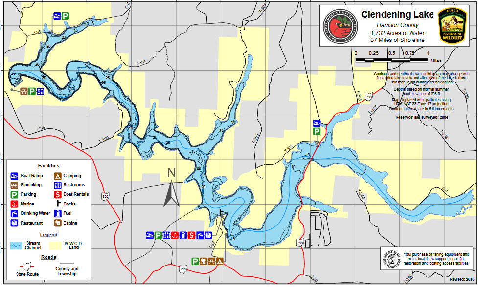
Clendening Lake is in southwestern Harrison County in Washington and Nottingham townships. The dam is at Tippecanoe off OH-800. OH-799 bisects the lake. Township roads provide access to the lake on all boundary lines. Access to I-77 is available at New Philadelphia which lies 25 miles to the north.
Clendening Lake, one of the flood control impoundments of the Muskingum Watershed Conservancy District, was constructed in Brushy Fork of Big Stillwater Creek. This 1,702-acre lake is mostly long, narrow, and winding and most of its 35.5 miles of shoreline are deeply wooded. There is a 10-horsepower outboard motor limit on this lake.
The Muskingum Watershed Conservancy District was organized under state law in 1933 for the primary purposes of flood control, conservation, and recreation. The first waters to form the permanent lakes were impounded in 1938. In 1939, the flood control aspect became the responsibility of the United States Army Corps of Engineers as part of the Ohio-Mississippi Flood Control Program.
Notable Trails
Clendening Lake Trails
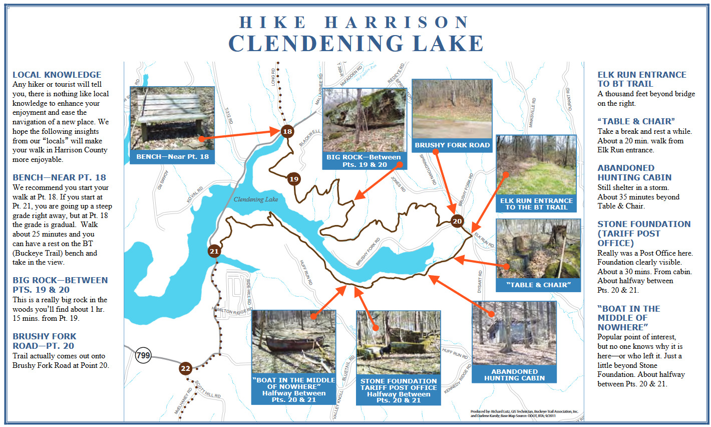
Several hikes of varied length on the Buckeye Trail start at “Point 18” or “Point 20” as seen on the maps on the left from the Buckeye Trail at Clendenening Lake brochure and map.
Please use hotspots for checklists on these trail sections:
Use for hikes from Points 18-20 –
Clendening Lake–Buckeye Trail, North of Brushy Fork Bay
Use for hikes from Points 20-21 –
Clendening Lake–Buckeye Trail, South of Brushy Fork Bay
Use for hikes on Brushy Fork Road from Point 20 –
Clendening Lake–Brushy Fork
Parking at Point 18 is available for one car on Clendening Lake Road (OH-799) or along Long Road.
For a first experience hiking in this area, there is a simple “out and back” 4-mile hike from Point 18 to the Big Rock between Points 19 and 20 (see map above). This is a hike of moderate difficulty. The first part is through early succession habitat from logging in 2016 going into near mature woods.
The entire trail marked on the map above is 10 miles from Point 18 to Point 22, returning 1 mile to your car via Clendening Lake Road (OH-799).
There are other hikes you can do in this area. There is lots of parking at Point 20.
Point 20 going south follows an abandoned township road and is very flat until 2.5 miles in. There is woodland swamp and early successional for the first .5 mile and then mature woods the rest of the way. This is a 5-mile out-and-back hike.
From Point 20 going north at the 1.75-mile mark, there is a spur trail (white blazes) that drops back down to Brushy Fork Road and back to your car for a nice 3-mile loop through mature woods (lots of Ceruleans and occasional drumming grouse) with the road portion along the lake and woodland swamp. Great loop! There is a large hill immediately on leaving the road but after that, it is an easy hike. See the map below for the route of this loop.
Point 21 is the least birdy of the hikes. It goes through planted pines the first .5 mile and then into mature woods for the rest.
During the winter from November to March, any of these can be turned into a loop by dropping to the lake and walking the exposed bank because the water level is dropped several feet.
Features
Restrooms on site
Content from Thanks to Scott Pendleton for describing these hikes. and Ohio Ornithological Society